
Hobart and Melbourne on track for their warmest winter in years
The warmest July in 142 years of records for Australia's southernmost capital has been followed by a warm August, resulting in winter as a whole tracking to be the warmest in 128 years.
So far this August, maximum and minimum temperatures in Hobart are averaging 1.9°C and 1.1°C, respectively, above the long-term August means. July ended with maximum and minimum temperature anomalies for Hobart near 3°C for both maxima and minima.
Melbourne has also had a warmer than average August to date, following a June and July that were also warmer than average.
There are a couple of cooler days in store for both cities this weekend and another likely on Thursday 31st behind cold fronts. But with only five days of the month to go, a couple of cool days will not shift the winter average by much. Hobart has the stand-out anomalies while Melbourne looks like it will turn out to the be warmest winter in about a decade, with 2013 and 2014 also having very warm winters.
Tracing the cause of the winter warmth could be an endless endeavour, but an immediate cause was the distinct lack of cold fronts steered over southeast Australia this season.
In general, a meandering wave-like pattern of upper winds, like that shown in the header picture, steer fronts alternately equatorward (in longwave troughs, coloured blue and purple) and poleward (in longwave ridges, coloured yellow and orange). Normally, this whole longwave pattern moves slowly eastward, steering cold fronts over different longitudes as the weeks progress–fronts for Perth one week, for Melbourne another.
However, this winter, longwave ridges have been largely anchored over southeast Australia while longwave troughs have sat preferentially over southwest Western Australia and also over New Zealand. As a result, the latter two locations got most of the fronts.
This can be seen in the figures below which show the longwave anomaly for this June and July compared to the long-term average for those months. The big blob of yellow points to fronts slipping south before they reached Tasmania, Victoria and New South Wales, either missing those regions entirely or crossing as weaker systems.
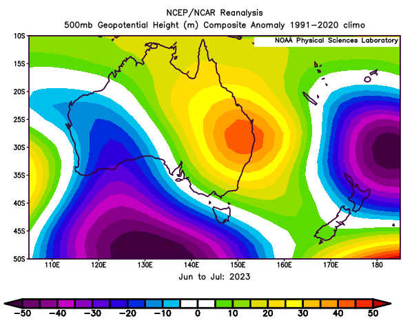
Image: Average long wave anomalies for June and July, 2023. Data/image provided by the NOAA/OAR/PSL, Boulder, Colorado, USA, from https://psl.noaa.gov/
Image: Animation showing cold fronts being mostly steered away from southeast Australia between mid-July and mid-August, 2023. Imagery: bom.gov.au
With the season now turning rapidly to spring, leading to the natural shift of cold fronts further south at all longitudes, time is running out for another strong cold front over southeast Australia this year.