
History-making tropical storm warning in effect as Hurricane Hilary bears down on California
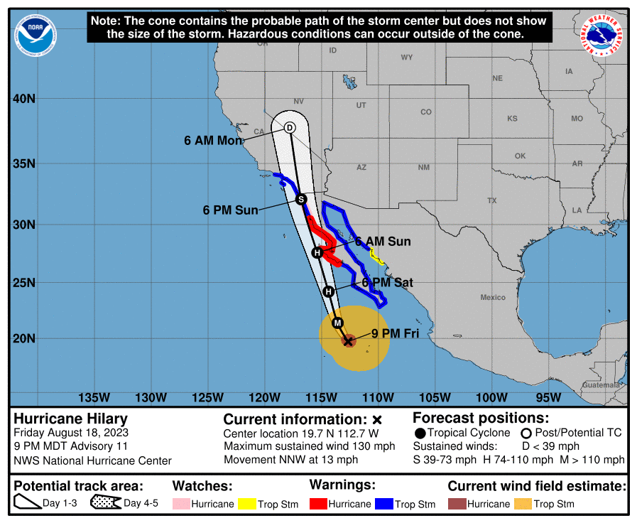
As Weatherzone meteorologist Maryam Al-Ansari wrote earlier today, we've been seeing a lot of hurricane activity in the East Pacific Ocean lately, thanks to warmer-than-normal ocean temperatures and higher-than-average atmospheric moisture. The one of biggest concern right now is Hurricane Hilary, currently a Category 4 system, which looks to begin impacting the Baja California peninsula of Mexico on Saturday night Pacific Daylight Time (PDT). It is then forecast to make landfall as a hurricane over the western Baja California coast before weakening to a Tropical Storm and making landfall again somewhere around the Mexico/California border on Sunday, triggering California’s first-ever Tropical Storm Warning (see image below).
‘It’s been 84 years’
While the movie buffs among us may recognise those words as the memeable quote from the fictional character Rose DeWitt Bukater in James Cameron’s blockbuster film Titanic, in this case they are directly relevant to California’s sparse history of tropical storm activity. If Hurricane Hilary makes landfall over the southern California coast as a tropical storm, it will be the first time in almost 84 years this has happened. In September 1939, Tropical Storm El Cordonazo made landfall near Long Beach, California, bringing record-breaking rainfall and, tragically, fatal flash-flooding. However, no tropical storm warning was ever issued for this system because prior to 1956, there was no U.S. National Hurricane Center to issue one.
At the time of writing, it looks like the centre of Tropical Storm Hilary should make landfall just south of the Mexico-California border. But just like Tropical Storm El Cordonazo, torrential rainfall and flash-flooding are the most significant risks associated with this system. Why? Because southern California and the Baja California peninsula are marked by mountain ranges. When a major storm system comes into contact with a mountain range, a process called “orographic lifting” can take place, causing the storm’s moist air to lift up over the mountains. As it does so, it cools and becomes more humid, leading to more intense condensation and rainfall than might otherwise be expected. The resulting rainfall then runs downhill, triggering intense flash-flooding and even landslides. The orographic lifting process is well-illustrated in this schematic from the University of Hawai’i:
.jpg)
After impacting southern California, the system is expected to weaken to a tropical depression as it moves north into Nevada. At this stage, NOAA’s National Hurricane Center is forecasting that “catastrophic and life-threatening flooding is likely over Baja California and the Southwestern U.S. through early next week.” It also warns that large swells generated by Hilary could cause life-threatening surf and rip conditions from southern California down to southwestern Mexico. This is definitely a storm system to take seriously.