Heavy rain threat for Sydney, Illawarra, Central Coast on Monday
Significant rainfall looms over the NSW coast and adjacent inland in the next couple of days, with the potential for deluges and flash flooding across the Metropolitan Sydney, Illawarra, and Central Coast regions.
A coastal trough, coupled with a highly moist southeasterly flow, is set to intensify showers this evening and into Monday 15th along the New South Wales coast and adjacent inland areas. Monday's rainfall holds the potential for deluges, raising the risk of flash flooding during the morning and afternoon. This may result in a notable disruption to workers’ commute as many people return to the office after Christmas breaks.
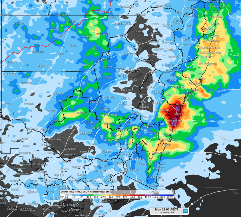
The most impacted regions are forecast to be north of Batemans Bay, with parts of the Illawarra, Sydney Metropolitan and Central Coast most at risk of heavy falls. Residents in these regions are urged to exercise heightened caution as 60-80mm of rain is anticipated, mainly falling during the morning and afternoon. If thunderstorms or particularly heavy showers develop, some coastal and adjacent inland areas could potentially receive 80-120mm (Figure).

figure. Accumulated rainfall to late evening Monday 15th according to ECMWF model.
In other regions along the NSW coast and adjacent inland, falls of 30-60mm are expected during Monday, with isolated heavy downpours also possible for parts of the Mid North Coast, with the potential for rainfall exceeding 100mm.
The rainfall over the Illawarra, Sydney and Central Coast districts will gradually transition into lighter showers as the evening approaches. Meanwhile, the Mid North Coast and Northern Rivers districts are likely to experience the most substantial rainfall in the afternoon and evening.
Wet weather should persist into Tuesday 16th with an additional 20-40mm of rain projected along the NSW coast and adjacent inland, as winds turn more northeasterly maintaining a moist airstream in the east.
Residents in affected regions are strongly encouraged to stay informed by checking the latest warnings at https://www.weatherzone.com.au/warnings.