
Heaviest rain in years falling in parts of eastern Australia
Heavy rain has inundated parts of Australia's eastern seaboard during the last 48 hours, with some places registering their heaviest falls in decades.
A persistent stream of moisture-laden air feeding into a near-stationary low pressure trough has caused heavy rain and severe thunderstorms in parts of Queensland and NSW during the last two days.
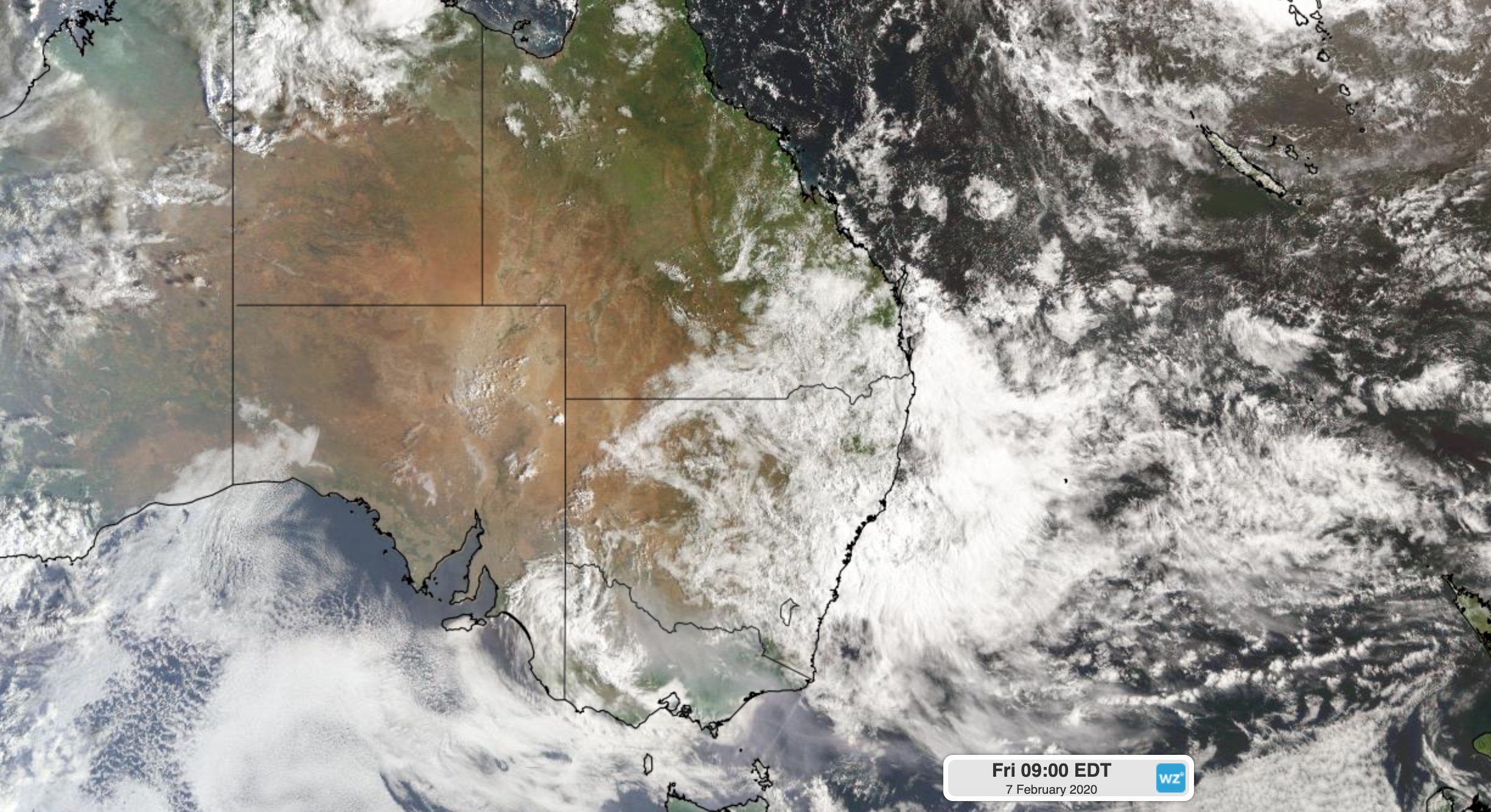
Image: A large mass of rain-bearing cloud over eastern Australia on Friday morning.
During the 24 hours to 9am on Thursday, the heaviest rain fell over southeast Queensland, where some places received more than 200mm. This included 260mm at Coops Corner and 230mm at Tin Can Bay. Double Island Point's 122mm was their heaviest rain in six years.
As the rain spread further south, persistent and heavy falls caused flooding in parts northeast NSW by Friday morning. The streets of Byron Bay were inundated after 275mm fell at the lighthouse during the 24 hours to 9am on Friday. This was the heaviest rain recorded at the site since it opened in 2002. Further south, Evans Head (200mm) and Coffs Harbour (123mm) both registered their heaviest rain in three years, while Sydney (79mm) picked up its best rain since November 2018.
Going to the shop in Byron Bay now requires a wetsuit pic.twitter.com/Aet6MdFFyL
— Norma Costello (@normcos) February 6, 2020
This week's rain is also bringing relief to some drought and fire-affected areas of eastern Australia.
In northwest NSW, Lightning Ridge's 58mm during the 24 hours to 9am on Friday was the outback town's heaviest rain since the middle of 2016. This came one day after Dubbo (28.2) collected their heaviest rain in a year.
At 11pm on Wednesday, there were still 62 fires burning in NSW. By 8pm on Thursday, this number had dropped to 42. The bulk of the state's fires are now confined to the southeastern quarter of the state, although many of these firegrouds will see some rain during the next few days.
Rain, showers and thunderstorms will continue to affect large areas of Queensland and NSW between Friday and Monday. The heaviest falls during this time will occur over eastern NSW, where a severe weather warning has been issued for heavy rain, flooding and damaging winds. A number of flood warnings are also in place for parts of Queensland and NSW.
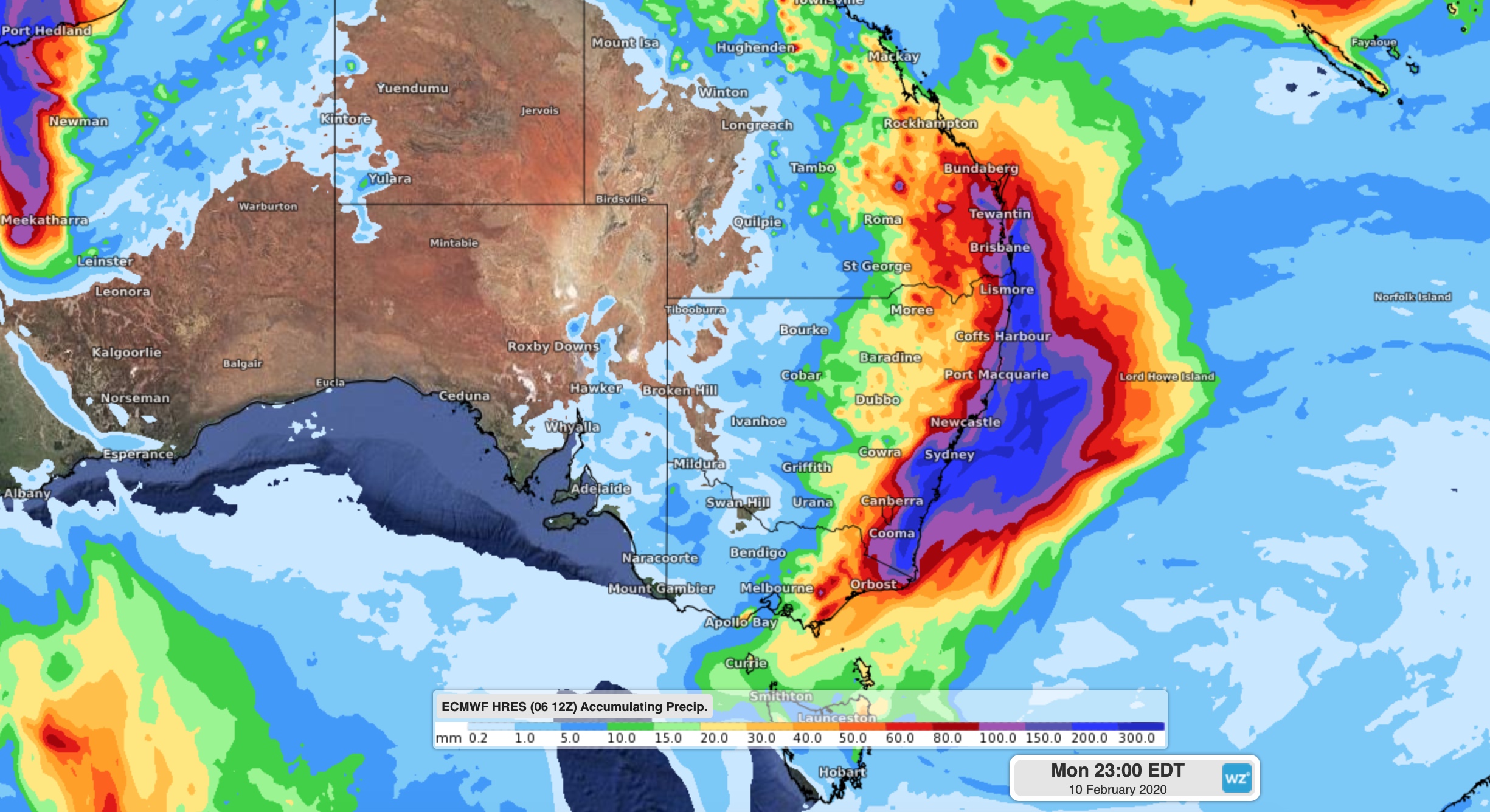
Image: Forecast accumulated rain during the next four days (Friday to Monday) according to the ECMWF-HRES model.
This spell of heavy rain follows a prolonged period of dry weather and widespread bushfires. The combination of heavy rain on drought and fire-affected land is likely to enhance the risk of flash flooding, landslides and may lead to contamination of some waterways.
The weather system causing this week's rain, thunderstorms and blustery wind is also producing powerful surf along parts of the NSW coast. A hazardous surf warning has been issued for most of the state's coastline on Friday and Saturday, with areas of coastal erosion likely during the next several days.
Anyone living in eastern NSW, particularly the southern half of the coast and adjacent ranges, should take the threat of severe weather into account before heading outside this weekend. Check the latest warnings at https://www.weatherzone.com.au/warnings.jsp for the most up-to-date information.