Heatwave grips the southeast as flooding hits the north and west
Once again, Australia finds itself under a spell of contrasting weather, each region with its own tale to tell.
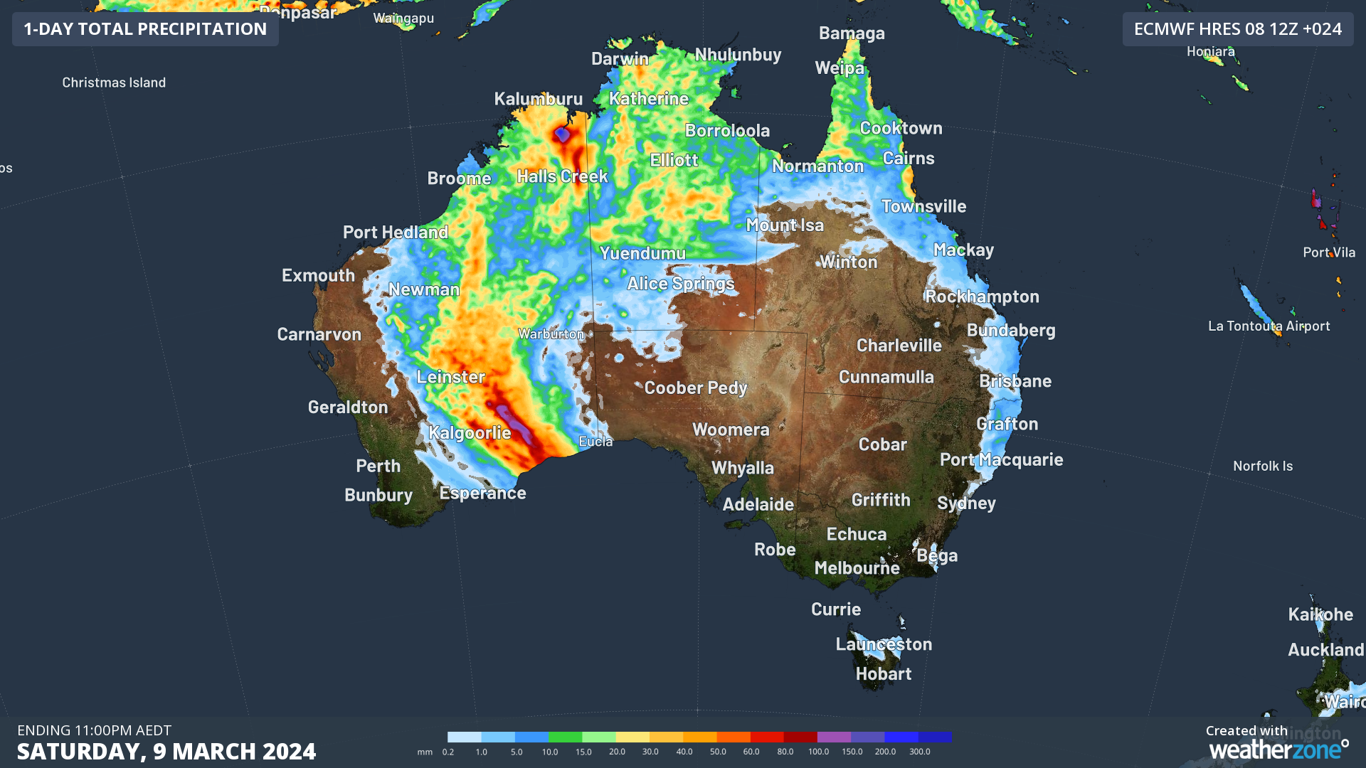
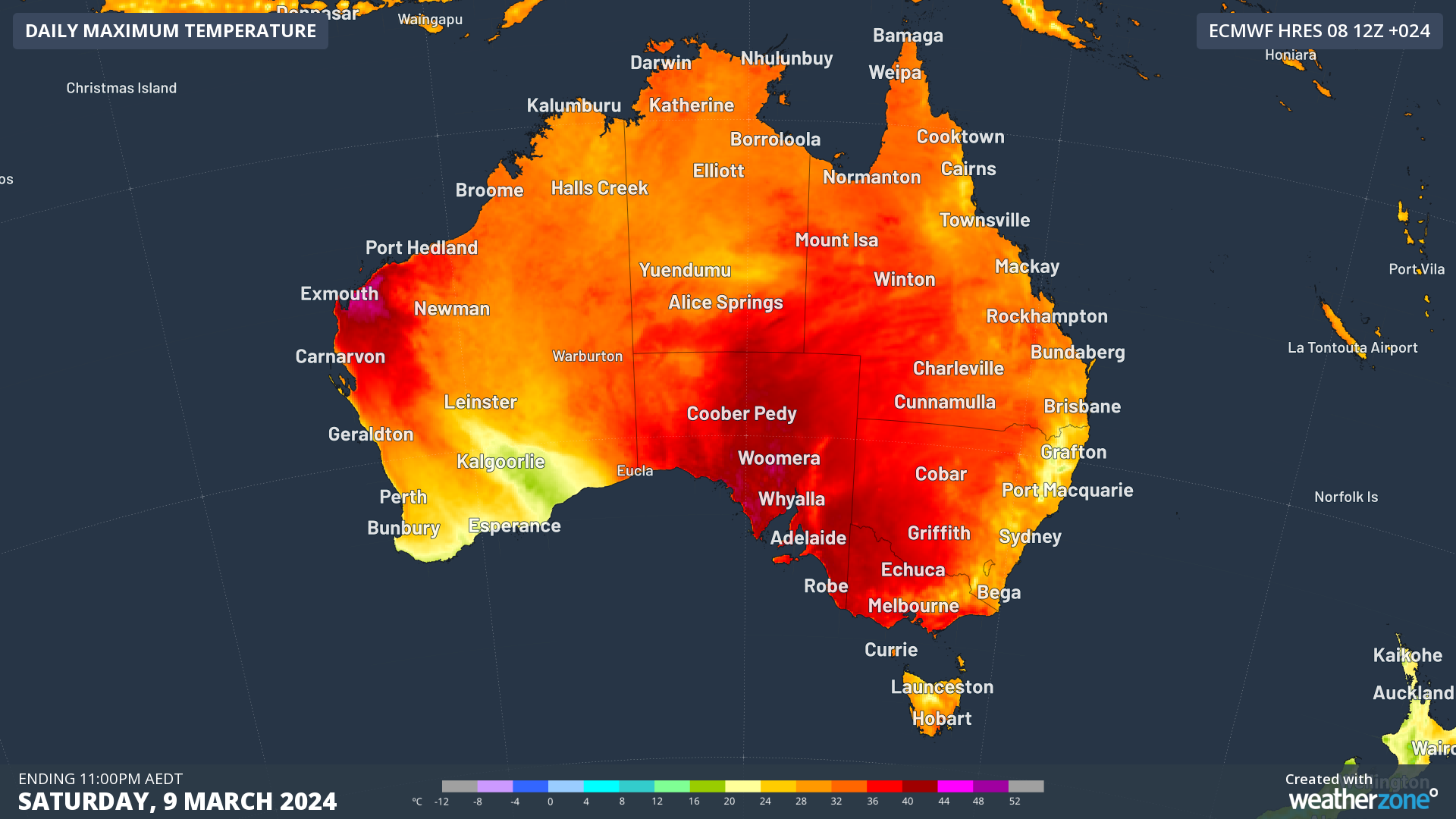
A developing monsoon trough in the northern tropics, along with a dynamic interplay between a trough and front, combined with abundant tropical moisture in WA’s southeast (Fig.1), heightens flood concerns. This is especially notable in WA’s southeast, where rainfall has been scarce for extended periods in recent months and even years. Meanwhile, southeast Australia is experiencing a starkly different situation, with a heatwave and dangerous fire conditions in SA and Vic (Fig. 2), fuelled by hot northerly winds.

Figure 1. 24-hour rainfall for Saturday 9th according to the ECMWF model.

Figure 2. Maximum temperature for Saturday 9th according to the ECMWF model.
A notable observation is the likelihood of these weather conditions remaining practically unchanged for the next two to three days. This persistence can be attributed to a stalled synoptic pattern marked by a continuous influx of tropical moisture in the north and west of the country, alongside a blocking high-pressure system entrenched over the Tasman Sea. As outlined in yesterday’s story, this scenario is expected to result in prolonged sweltering conditions in the southeast, with Adelaide and Melbourne anticipated to endure a series of hot days and warm nights until at least Monday, with daytime temperatures soaring into the high 30s. On the other side of the country, the trough in WA’s southeast will continue to deliver heavy rainfall until around mid-next week.
To provide insight into the upcoming weather, let's examine rainfall observations recorded in the northern tropics and over WA’s southeast, along with temperature observations in the southeast.
In the northern tropics, noteworthy figures include Menavale (QLD) which received 170mm to 9am EST, the highest March rainfall in 6 years. Bingil Bay (QLD) saw 133mm, the most in 3 years, while multiple location across the North Tropical Coast saw rainfall ranging between 50 and 130 mm. Meanwhile, in WA’s north, Argyle Aerodrome (WA) registered 130mm, the highest in a decade. Wyndham Aerodrome (WA) recorded 114mm, the most in over 7 years and the highest March rainfall in 18 years. Last, but not least, Kachana experienced 140mm, the highest March rainfall in over 7 years.
In southeastern WA, Kalgoorlie-Boulder experienced 50mm of rain to 9am WST, marking the highest March rainfall in 11 years. Notably, Edjudina recorded 58mm of rainfall, marking the highest March rainfall in 7 years.
In the southeast, minimum temperatures today have reached remarkable highs across NSW, VIC, and SA for the month of March. In South Australia, Adelaide saw a minimum of 28°C, the hottest in 5 years and two degrees above the March average. Stenhouse Bay experienced its highest minimum temperature in over 28 years, while Noarlunga recorded the highest in over 23 years. In Victoria, Gabo Island and Mallacoota recorded their warmest March temperatures in over 46 and 29 years, respectively. Additionally, various locations across Victoria and NSW observed their highest March minimums in 3 to 8 years.
Daytime temperatures have soared in SA and VIC, with records broken after decades. Edithburg and Clare in SA saw their highest March temperatures in 31 and 28 years, respectively, while Walpeup and Bairnsdale in VIC experienced their highest March temperatures in 26 and 24 years, respectively. Adelaide and Melbourne also had their hottest March day in 5 years (Adelaide with a whopping reading of 39.9C at 14:56 ACDT and Melbourne (Olympic Park) with a maximum temperature of 37.1C at 16:15 AEDT.
Prepare for more heavy rain in the north and WA's southeast, and scorching weather in the southeast, as this stalled pattern persists in the coming days. Stay informed with the latest warnings and updates on Weatherzone.