Heat spreading across Australia's southeast a chance to break records
Warmth is spreading across Australia's centre and southeast while cold fronts slip away, allowing heat to build into near-record highs for this early in the season.
Many places across South Australia, Tasmania, Victoria, the ACT and New South Wales have already experienced their warmest spells for this early in the season in 10-20 years.
It has been the warmest September spell in:
- 79 years in Victoria's Essendon (averaging a maximum of 24.2 degrees in the five days to Saturday 16th)
- 36 years in Victoria's Tullamarine and SA's Mt Gambier (averaging a maximum of 24.2 degrees in the five days to Saturday 16th, and 23.8 degrees in the three days to Thursday 14th respectively)
- 27 years in NSW's Bombala (averaging a maximum of 23.0 degrees in the four days to Saturday 16th)
- 24 years in Tasmania's Smithton (averaging a maximum of 18.1 degrees in the four days to Friday 15th)
- 22 years in Victoria's Falls Creek and Mt Buller (both averaging a maximum of 12.9 degrees in the three days to Thursday 14th and Saturday 16th respectively)
- 17 years in SA's Port Lincoln (averaging a maximum of 26.1 degrees in the five days to Friday 15th)
A cooler change has since moved through Tasmania and southern parts of SA and Victoria but it's only weak, so temperatures have been staying above the long-term average and are on the rise again.
During the next several days the most intense heat will be focussed across inland SA, northern Victoria, the ACT and NSW. But even in the areas where the heat is not so intense, records are still likely to be broken, including in Melbourne. The Victorian capital is on track to stretch its run of 20-degree September days out to eight (today is day five of this so-far unbroken run) https://www.weatherzone.com.au/news/record-september-warm-spell-set-to-bake-melbourne/1501245.
Another capital that is forecast to achieve a record-long September warm spell is Sydney.
In Sydney's 165-year history of temperature recordings, Observatory Hill has only ever strung together two 30-degree days in September, most recently in 2014. With the arrival of the warming winds, the city has a few chances to set a new September record between now and Wednesday. Cooling afternoon sea breezes are a high chance on Sunday and Monday making these two days a bit iffy regarding 30 degrees.
However, western suburbs will get little or no afternoon cooling from these sea breezes, making 30 degrees a relative cinch. in 80 years of records, Richmond has had as many as four consecutive 30-degree days in September, most recently in 2013, and should manage five between now and Wednesday.
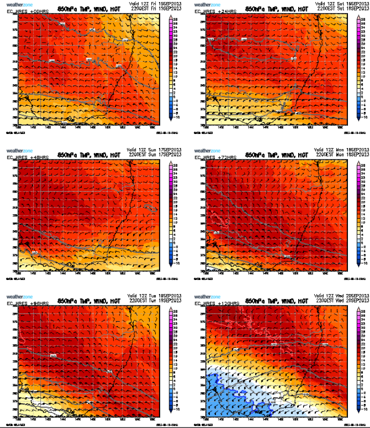
This unseasonably long and warm spell has largely been due to a positive Indian Ocean Dipole (IOD) and a split jetstream favouring a blocking high-pressure area. The positive IOD has led to skies being generally cloud-free in northwestern Australia, allowing heat to build as a blocking high over the Tasman Sea deflects cold fronts south of the mainland. This setup has meant some of the heat filtered to the country's southeast in persistent northerly winds, causing the region to steadily heat up with minimal interruption.

Image: ECMWF model indicating temperature, wind and height at 850hPa (about 1.5km above sea level).
Come mid-week, the high should break down enough to give a clearer passage for a front to penetrate the southeast, bringing colder winds and forcing the warm-to-hot air further north.