First Tropical Cyclone of 2025
Tropical Cyclone (TC) Dikeledi was declared at 11:00am AEDT on Saturday 11th of January just off the northeast coast of Madagascar, after having been a tropical storm in the southwest Indian Ocean for the last 6 days.
Though TC Dikeledi is the first cyclone of 2025, it isn’t the first tropical cyclone of the South West Indian Ocean 2024-2025 season. TC Chido had skimmed the north of Madagascar and devasted the French island of Mayotte between the 9th and 15th December in 2024. TC Chido was the most devastating TC for the region in the past 90 years, resulting in more than 675 million US dollars worth of damages, thousands of people injured and tragically 39 deaths.
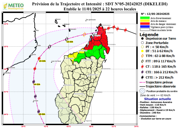
The consequences of TC Dikeledi look to be more severe according to local meteorologists, despite it not expected to be as strong. The regions of Diana, Sava and northern Sofia have red cyclone alerts whilst coastal Boeny is in a yellow alert and the rest of Sofia, Boeny and northern Analanjirofo are in a green alert (Fig. 1). These alerts encompass widespread flooding, riverine flooding and landslides for the north of the country, with rainfall totals over 100mm and 130km/h winds expected. Storm surges and swells over 8 meters are also forecast for the northeast coast.

Fig. 1) Cyclone Warning issued by Meteo Madagascar on 11/01/2025 for the next 22-hours
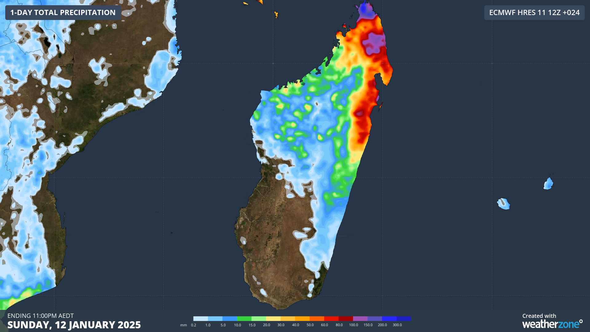
TC Dikeledi has crossed over the Diana, Sava and Sophia regions of far northern Madagascar with 140km/h winds gusting at 170km/h. Local rainfall of 50mm/h has been observed over areas of the country’s east coast, but the limited available weather stations make it difficult to know the rainfall total at cyclone affected areas. However, models are showing 24hr rainfall exceeding 150mm over the north and eastern coasts of the country, and around 300mm on the western flank of the system (Fig. 2).

Fig. 2) 24-hour rainfall accumulation forecast from 11am AEDT, as shown by ECMWF.
Flooding of low-lying areas still serves as a very great risk, with it resulting in flash flooding due to insufficient drainage, landslides and an increase in water-borne diseases such as dengue fever, cholera and malaria. More than 22,500 children are at risk of injury, illness or losing their homes and school according to Save the Children.
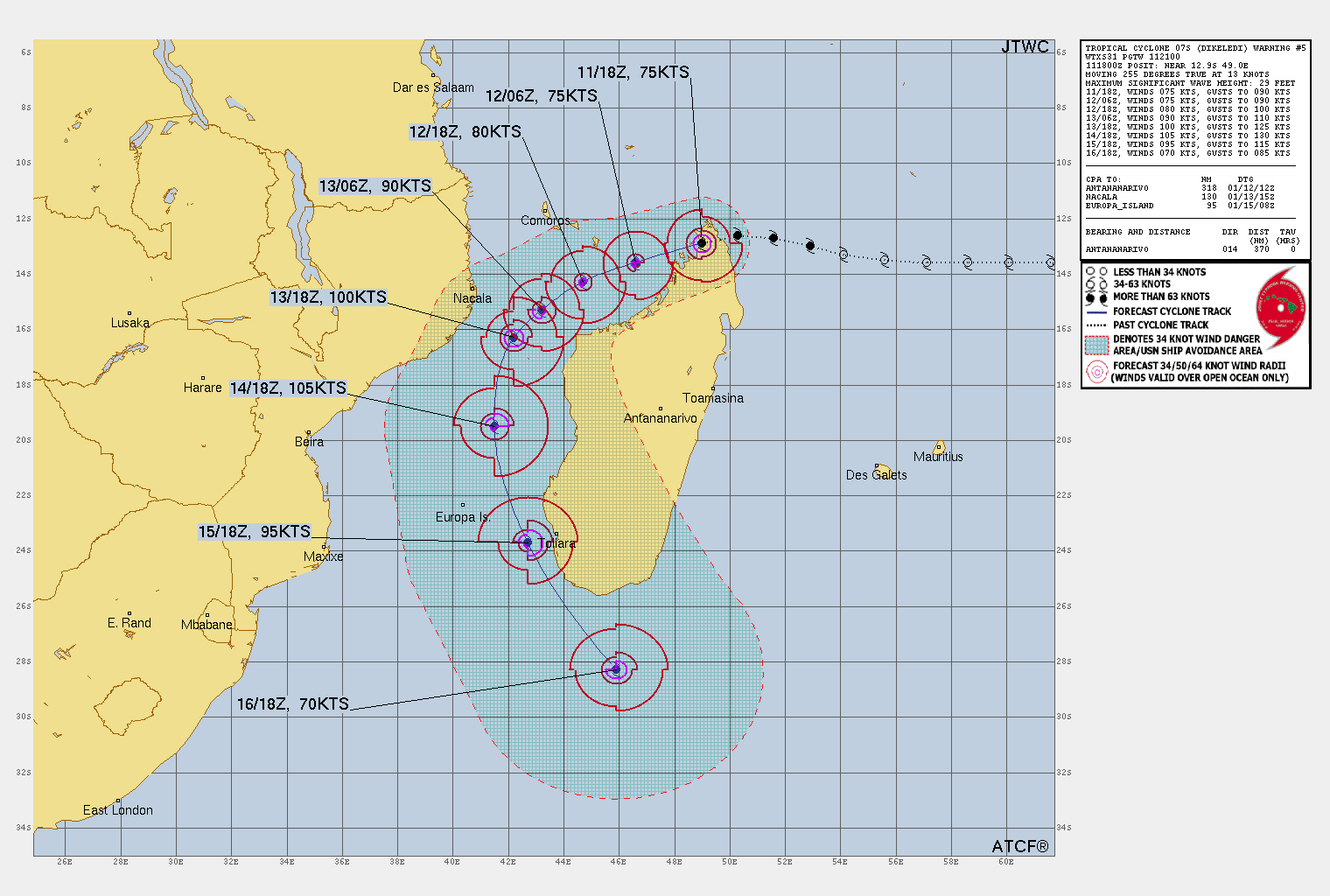
TC Dikeledi is forecast to move parallel to the Madagascar’s northwest coastline as it moves through the Mozambique channel. Whilst in the channel, the cyclone is expected to intensify into a category 3 tropical cyclone, before moving south of the country and back into the Indian Ocean (Fig. 3).

Fig. 3) TC Dikeledi’s forecast track through the Mozambique channel, by the Joint Typhoon Warning Center
Though it will not reach the same category and hazardous status as TC Chido did last December, TC Dikeledi serves as a reminder that a disaster isn’t defined by how strong a particular hazard or storm is, but how widespread and devastating its impact is.