
Do not write La Nina off just yet
La Niña has passed its peak and is showing signs that it may be losing its grip on Australia’s weather. But don’t put the brolly away just yet, because a weakening La Niña can still have a big influence on the weather and climate in Australia.
La Niña was officially declared by the Bureau of Meteorology towards the end of spring last year. This coincided with Australia registering its wettest November on record. Two months later, NSW had its wettest January in 26 years and SA had its wettest January in 38 years.
Prolific and record-breaking rainfall in central Australia during January caused widespread flooding that damaged major intestate road and railway networks. Heavy falls from last month also inundated rivers in western QLD, with major flood peaks still making their way downstream several weeks later in the middle of February.
The footprint of this La Niña has been clear to see across the Australian landscape, with blooms of vegetation and flooded rivers strewn across the typically barren outback.
The three maps below show the total vegetation cover anomalies at the start of January in 2020, 2021 and 2022. The most recent map features large areas of above-average vegetation cover for this time of year, partially in response to La Niña.
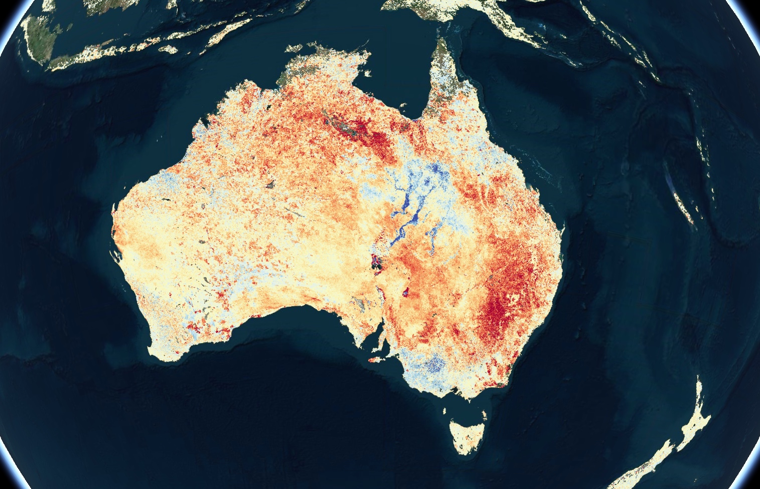
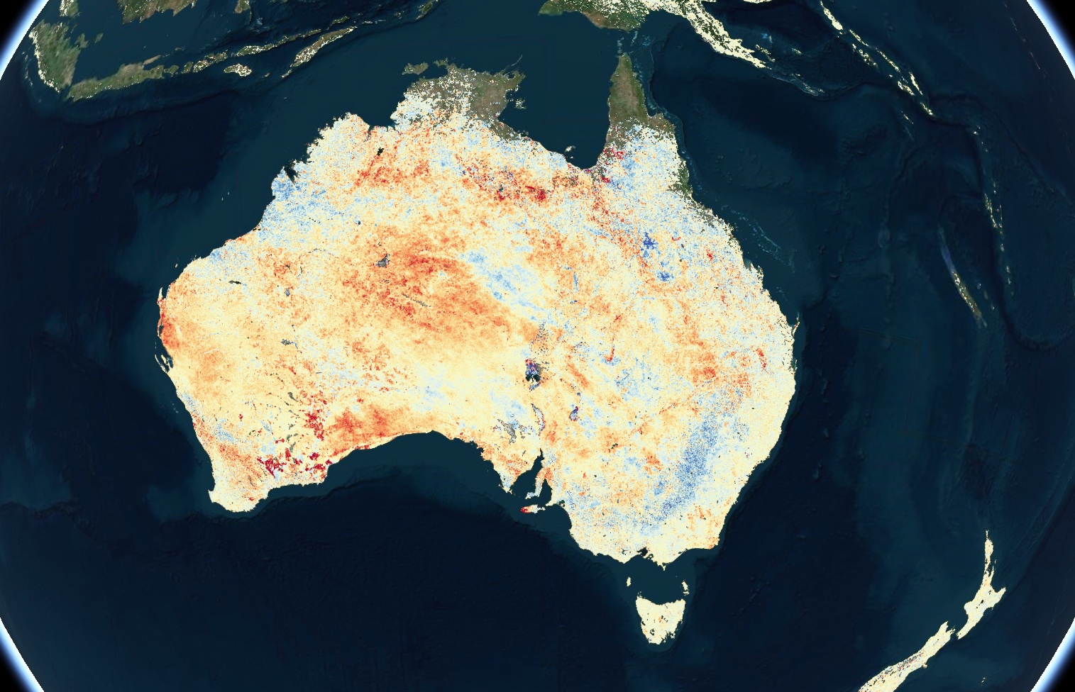
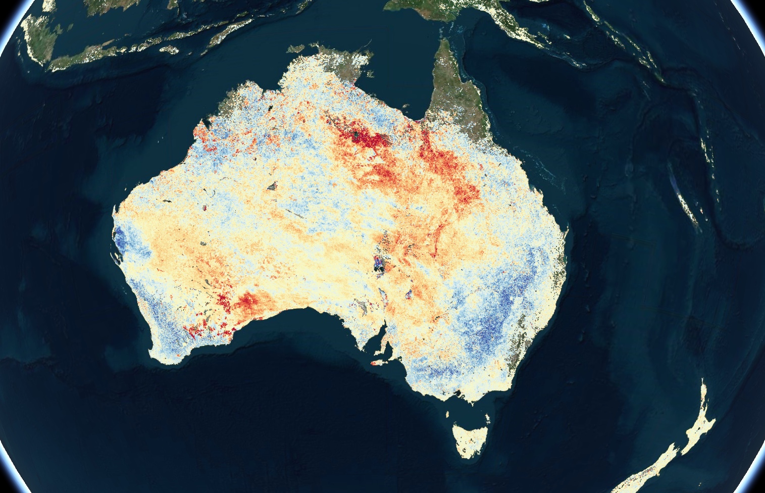
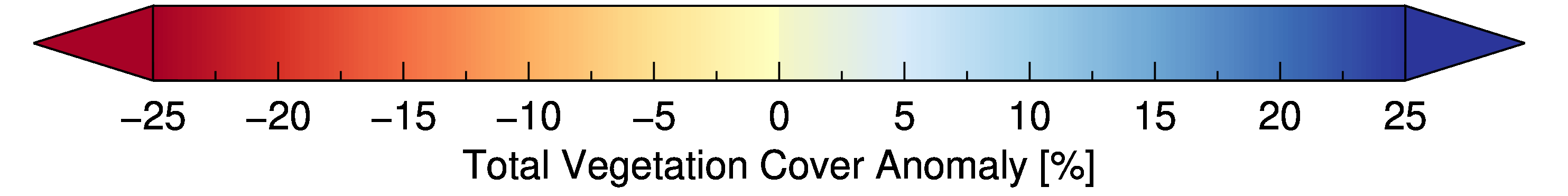
Images: National monthly vegetation cover anomalies on January 1 in 2020 (top), 2021 (middle) and 2022 (bottom). Red areas show below average vegetation cover for early January and blue shows above average vegetation cover. Source: https://map.drought.gov.au/
So, what can we expect to see now that La Niña is weakening?
After reaching a peak in January, La Niña has been gradually weakening in the Pacific Ocean over the last few weeks. This has coincided with a noticeable lull in rainfall over much of Australia during the first fortnight of February.
However, the recent spell of drier weather in Australia does not mean that La Niña has lost its influence on Australia's climate. It is common for rainfall to ebb and flow during La Niña evens, with some months exceptionally wet and others remarkably dry.
This month’s noticeable reduction in rainfall has also been influenced by the state of two other broadscale climate drivers:
- The Madden Julian Oscillation (MJO) moving into a region that reduces rainfall in Australia.
- The Southern Annular Mode (SAM) dipping into a weakly negative phase, which can reduce rain in eastern Australia during summer.
Despite the recent spell of dry weather in Australia, La Niña is likely to persist until at least mid-autumn in the Southern Hemisphere and should continue to influence Australia’s weather in the coming weeks and months.
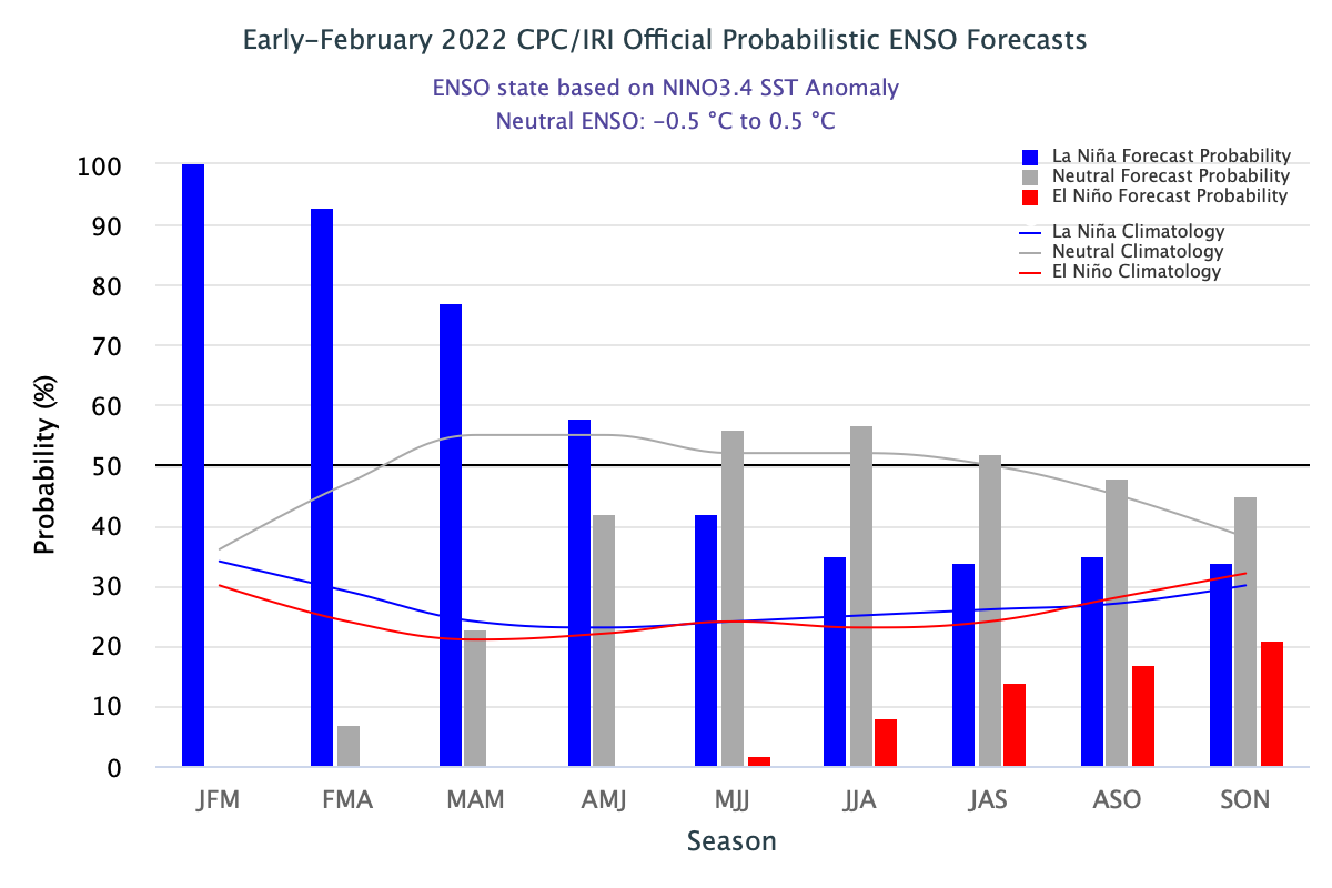
Image: ENSO forecast from the NOAA Climate Prediction Centre, showing that La Niña is expected to last into the Southern Hemdisphere’s autumn before the Pacific Ocean returns to a neutral state in late-autumn or winter. Source: NOAA/CPC
Seasonal forecast models suggest that wetter than average conditions will continue in parts of Australia at least until mid-Autumn, under the influence of this weakening La Niña. Above-average rain may continue into late-autumn as residual warm water lingering near Australia provides elevated levels of moisture in the atmosphere.
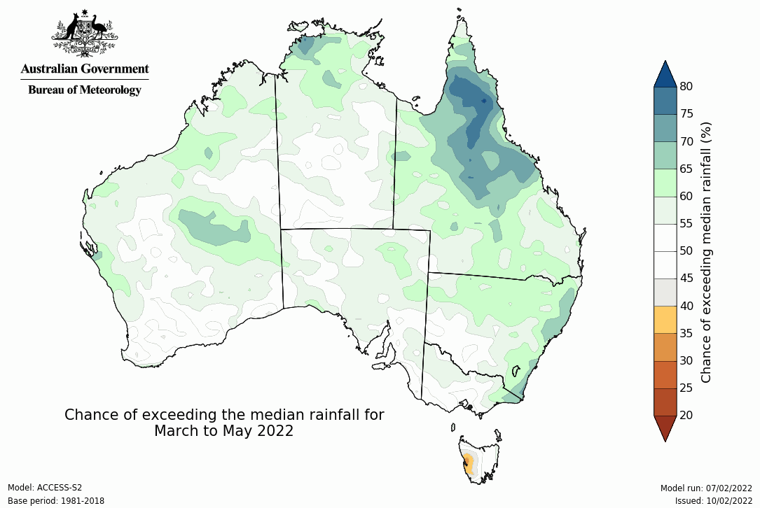
Image: Rainfall outlook for autumn (March, April and May). Source: Bureau of Meteorology.
Daytime temperatures are expected to be near or slightly above the long-term average this autumn across much of Australia. However, warmer days are forecast for the southwest corner of WA, northern QLD, and parts of southeastern Australiam and cooler days could be a feature in parts of NSW.
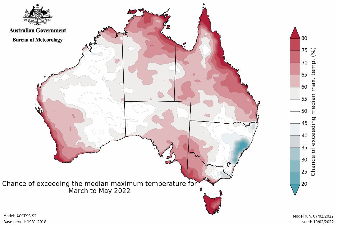
Image: Maximum temperature outlook for autumn (March, April and May). Source: Bureau of Meteorology.
Overnight temperatures have been unusually warm across Australia during summer thanks to an abundance of cloud trapping the heat in overnight. Night-time temperatures will continue to be warm into Autumn, at least until the influence of La Niña subsides.
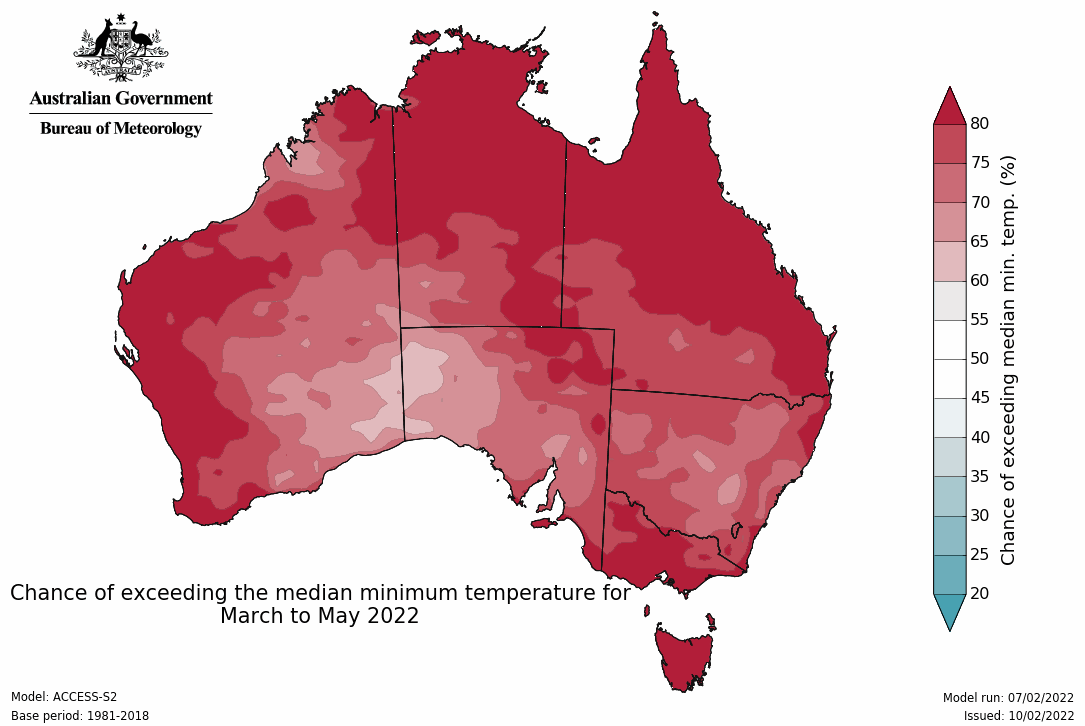
Image: Minumum temperature outlook for autumn (March, April and May). Source: Bureau of Meteorology.
Tropical cyclones in autumn
While Australia has had a relatively quiet tropical cyclone season to date, February and March are typically the most active months for tropical cyclone activity in the Australian region. March is also the most likely month for a category five tropical cyclone to pop up in Australia’s western area of responsibility.
In addition to this being the climatological peak of the cyclone season for Australia, La Niña will further increase the likelihood of tropical cyclone development in the coming weeks, until at least mid-autumn.
The Madden Julian Oscillation (MJO) may also bolster the influence of La Niña by increasing the chance of tropical cyclone formation as it moves near the Australian region during the second half of February.
So, while La Niña has passed its peak, it could still play a big role in Australia's weather and climate over the next couple of months.