
Darwin hasn't seen September rain like this for decades
Rare dry season rain is soaking parts of northern Australia this week, with Darwin just copping its heaviest September rain in 43 years.
Northern Australia is still technically in its dry season, which officially runs from May to September and is characterised by very little rainfall.
While Darwin is notorious for heavy rain and thunderstorms in the wet season, the city usually receives about 44 mm of rain during an average dry season. However, a rare September soaking delivered more than this entire seasonal average within a few hours early on Tuesday morning.
Darwin Airport picked up 52.4 mm of rain between 1am and 9am on Tuesday morning, with most of this falling before 6am. This was Darwin’s highest daily rainfall in September since 1981 and it more than tripled the city’s monthly average for September.
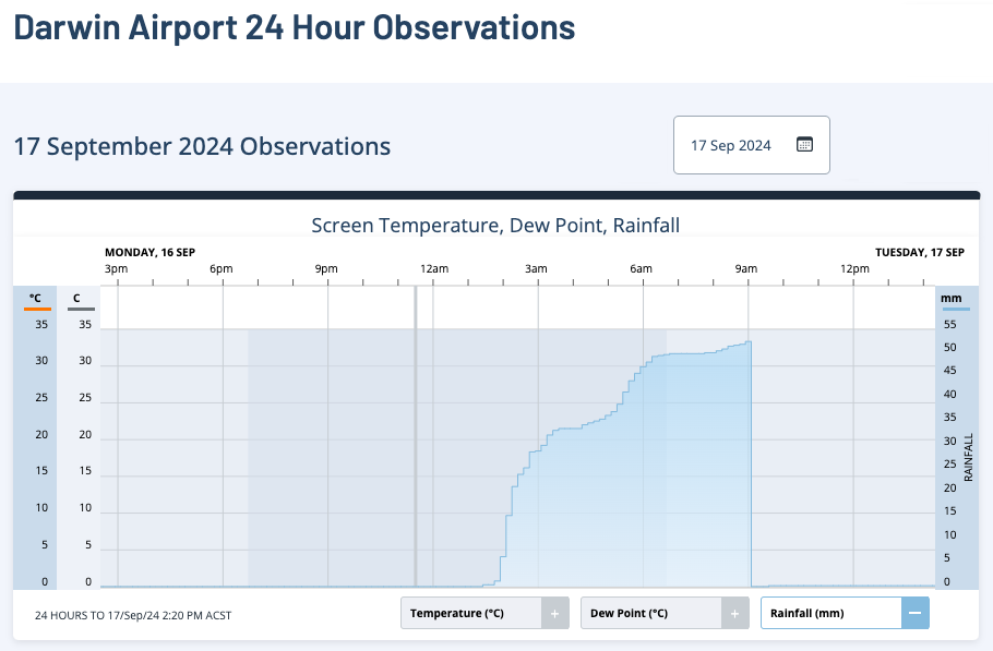
Image: Darwin rainfall observations on Tuesday morning.
The unusually heavy dry season rain was caused by humid easterly winds feeding into an upper-level trough sitting above northern WA. Warmer-than-average sea surface temperatures near northern Australia are likely contributing to the atmospheric moisture that produced Tuesday morning’s rainfall.
Showers will ease over northern Australia on Wednesday and Thursday as the upper-level trough weakens.
Looking ahead, another round of heavier rain and thunderstorms could develop over parts of WA and the NT late this week and early next week as a new trough develops over WA. There is still some uncertainty regarding this system, so be sure to check the latest forecasts and warnings throughout the next week.