Cowra's first 14m flood since 1952 as Forbes residents evacuate
The Lachlan River at Cowra exceeded 14 metres on Monday night, reaching a height not seen in the town since 1952. Meanwhile, the SES is warning residents in low-lying areas of Forbes to evacuate ahead of record-challenging flooding expected later this week.
The animation below shows a barrage of thunderstorms causing widespread and heavy rain over Central West NSW on Sunday into Monday morning.
Video: Composite satellite, radar and lightning observations showing thunderstorms hitting western NSW on Sunday into Monday morning.
Some of the heaviest rain in NSW on Sunday fell in the Lachlan River catchment, which was already experiencing major flooding before the weekend’s burst of wet and stormy weather arrived.
Forbes collected 118 mm of rain during the 24 hours to 9am on Monday, which was its heaviest daily rainfall in records dating back to 1875. Further east, Canowindra’s 120 mm over the same period was its highest daily total since 1956.
This sudden influx of water caused river levels to rise rapidly, exacerbated major flooding along the Lachlan River.
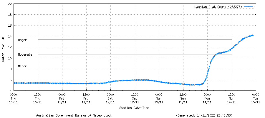
In response to Sunday’s rain and ongoing water from Wyangala Dam, the Lachlan River at Cowra hit 14 metres at 8:30pm on Monday and by 10:15pm, it had risen to 14.19 metres. This is the first time Cowra has seen a 14-metre flood since 1952.

Image: River level observations for the Lachlan River at Cowra. Source: Bureau of Meteorology.
According to the Bureau of Meteorology, the Lachlan River at Forbes Iron Bridge is expected to exceed the major flood level on Tuesday and may reach around 10.8 metres on Thursday. This is on par with the site’s record flood peak from June 1952.
The SES has issued numerous Flood Emergency Warnings in western NSW directing people to evacuate, including low-lying areas of Forbes CBD.
Wyangala Dam overflowing, proper Hollywood disaster flick stuff. pic.twitter.com/tHTpBaHcjp
— One Angry Eyebrow: Furniture Fluffer (@angry_eyebrow) November 14, 2022
River levels in the Lachlan River could exceed the predicted peak heights in the coming days. Be sure to check the latest flood warnings and river levels for the most up-to-date information and follow SES evacuation advice.