
Category 5 Hurricane Milton barrels towards Florida
Hurricane Milton has become one the strongest hurricanes on record in the Atlantic Basin, with gusts up to 325km/h, and is moving quickly towards Florida.
Record intensification
Hurricane Milton initially formed as a tropical storm over the weekend but underwent the fastest intensification of any Gulf of Mexico tropical cyclone. In a 24-hour period, the central pressure fell from 981hPa to 897hPa, while sustained winds increased by 145 km/h (90 mph) over the same time period.
The central pressure of 897hPa also makes Hurricane Milton the fifth most intense hurricane in the Atlantic Basic on record, and the strongest since 2005. Below you can see the NOAA aircraft “Miss Piggy”, the hurricane reconnaissance aircraft that made this measurement, encounter severe turbulence in the eyewall, followed by the eerie calm of the eye.
Bumpy ride into Hurricane #Milton on @NOAA WP-3D Orion #NOAA43 "Miss Piggy" to collect data to help improve the forecast and support hurricane research.
— NOAA Aircraft Operations Center (@NOAA_HurrHunter) October 8, 2024
Visit https://t.co/3phpgKNx0q for the latest forecasts and advisories
Visit https://t.co/UoRa967zK0 for information that you… pic.twitter.com/ezmXu2Zqta
Weakening and reintensification
Since its peak on Monday evening US time, Milton has undergone an eyewall replacement cycle, a process in which a new, large eye forms and surrounds the initial smaller eye. While this process is happening, a tropical cyclone will lose some of its strength, but once the process is complete, the system often becomes larger and more organised than before.
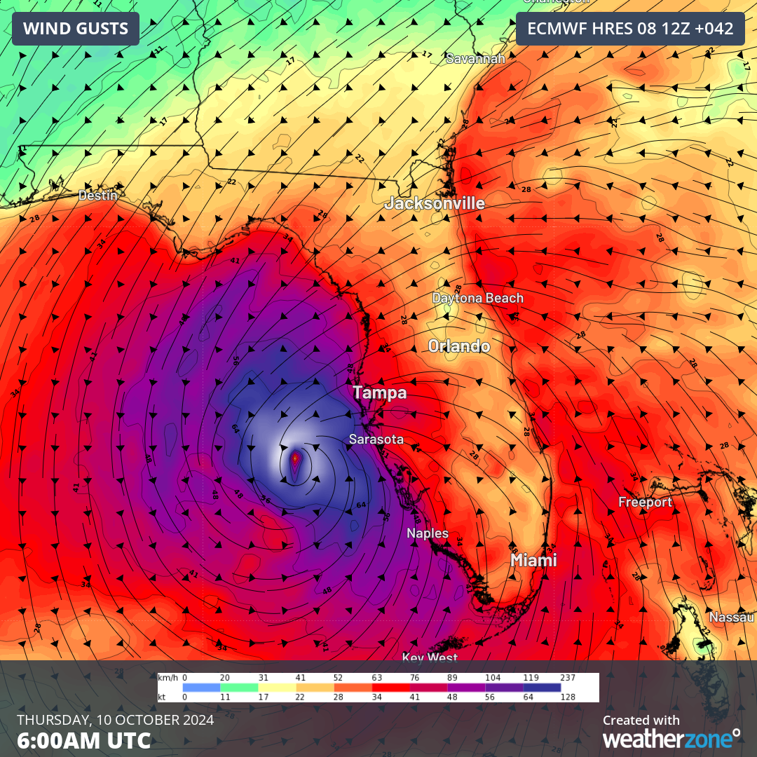
Hurricane Milton did weaken down to a category 4 system during Tuesday morning. But with that process now completed as of Tuesday evening, it has since reintensified to a category 5 hurricane, with 1-minute sustained winds of 260km/h (165mph), and gusts up to 325km/h (200mph).
Landfall over Florida
Hurricane Milton is now picking up speed, barrelling towards central Florida. It is expected to make landfall close to the populated city of Tampa on Wednesday afternoon US time, before crossing over Orlando and Daytona Beach and making its way into the North Atlantic Ocean.
Milton’s landfall is expected to be brief but violent, most likely as a category 3 or 4 system on the US scale, as the system weakens in response to less favourable conditions on its way to the coast. At landfall, 1-minute sustained winds of 215km/h (135mph), gusting up to 260km/h (165mph) are expected.
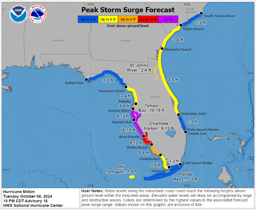
While the winds will be easing slightly as the hurricane makes landfall, the bulk of the storm surge has already been created and will be higher than a typical hurricane of this strength. A storm surge of 10-15 ft (3-5m) is forecast from the south and east sides of the system.
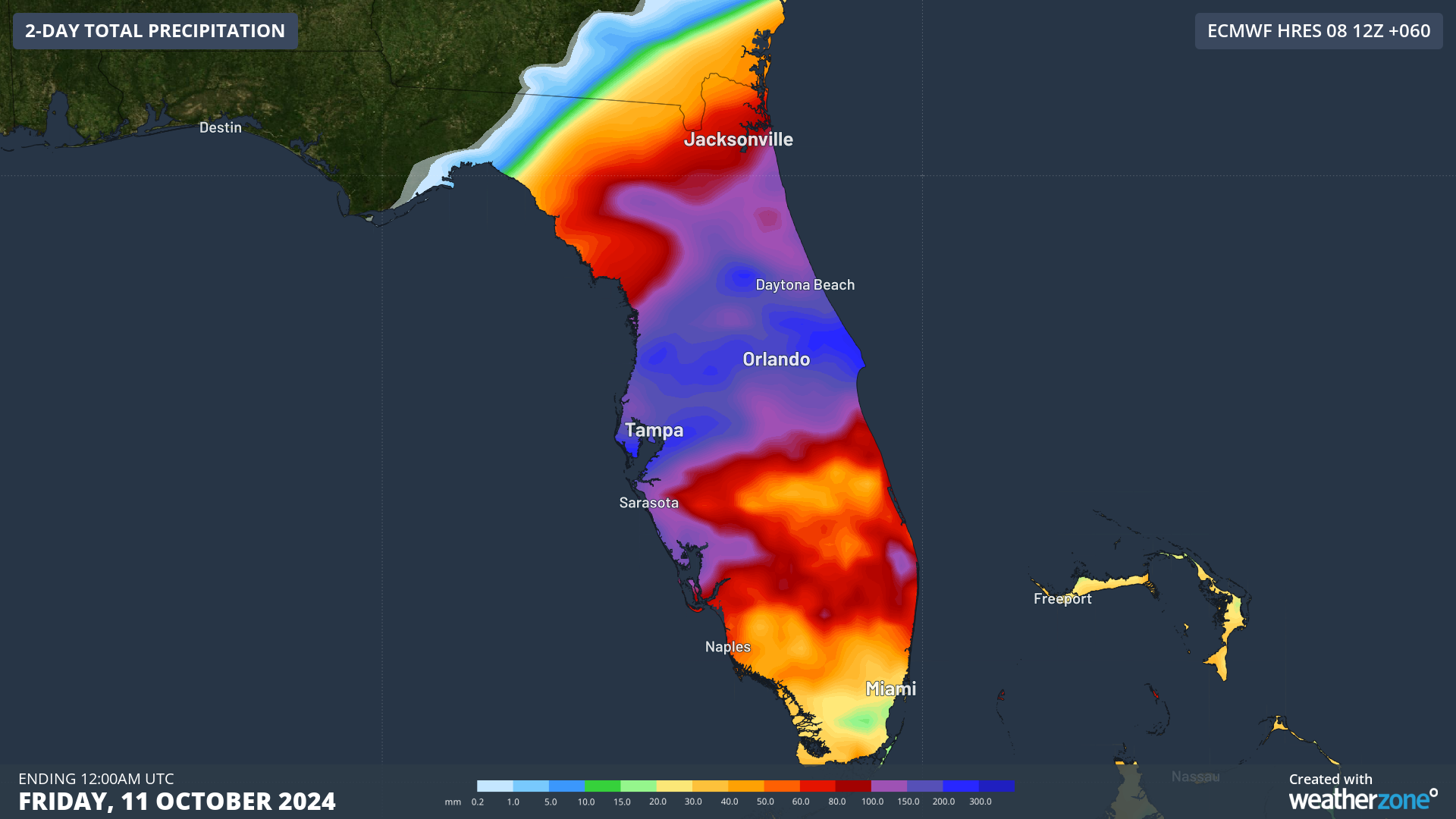
Due to the fast movement of Milton, rainfall is likely to be very intense but short-lived. Forecast rainfall of 100-200mm is expected to fall in just a 12-hour period as the system roars over Florida on Thursday evening. Mixed with the storm surge, this can lead to rivers unable to drain into the ocean, therefore increasing the chance of flooding.
Florida’s Evacuation
Due to the destructive and life-threatening forecast, as well as a state recovering from Hurricane Helene only two weeks ago, mass evacuations are occurring in Florida. 22 million people, the same population as all of Australia in 2010, are all heading out of danger, resulting in traffic chaos.
Wow! Check out this bumper-to-bumper clip from an I-75 Live Traffic Cam just now looking East away from Naples, #Florida as residents Evacuate. Notice the National Guard moving in as Cat 5 #HurricaneMilton approaches the state. #flwx #Milton pic.twitter.com/OnKvVo7Bum
— LiveCamChaser (@LiveCamChaser) October 8, 2024
You can see all the warnings and official advice from the National Hurricane Center here.