
‘Bomb cyclone’ to spread severe weather through US later this week
Another big spring storm system will cause strong winds, heavy snow, potential blizzard conditions, freezing rain, and severe storms across the US this week.
Bomb cyclone on the way
A low pressure system is expected to rapidly intensify as it moves from the Rockies into the Central Plains on Friday, March 14. This low may intensify fast enough to be classified as a ‘bomb cyclone’, which refers to a low pressure system where the central pressure drops by 24 millibars (mb) over a 24-hour period at 60 degrees latitude, or 14 mb over a 24-hour period at 30 degrees latitude.
Bomb cyclones are dangerous systems that typically produce powerful winds and heavy precipitation. With this week’s low being positioned closer to 40 degrees latitude in northeast Colorado on Friday, a drop of approximately 18 mb would suffice for it to be classed as a bomb cyclone. Recent runs of the European ECMWF and American GFS models are somewhere in the range of a 20-25 mb drop in 24 hours, which is more than enough to meet the definition.
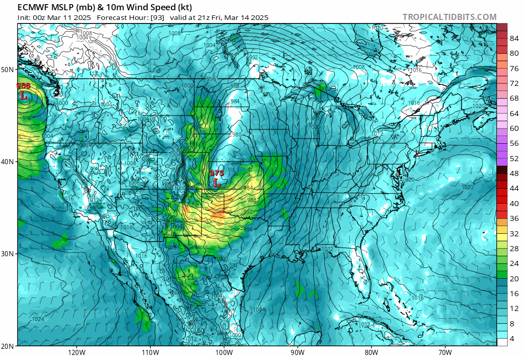
Image: Forecast wind speed and mean sea level pressure at 21 UTC on Friday, March 14. Strong winds are forecast to develop over the Plains, with wind gusts exceeding the labeled sustained winds shown here. Source: tropicaltidbits.com
The low-pressure center is forecast to move from the Central Plains northeast through the Upper Midwest for Saturday, March 15, then into Hudson Bay on Sunday, March 16. A cold front associated with the low will also sweep across the country over the weekend, moving to the East Coast on Sunday night before exiting offshore early Monday, March 17.
Get ready for wind, rain, ice and snow
Before getting into the Plains, the system will have already brought widespread precipitation and strong winds to the Western US, including areas of heavy mountain snow, on Wednesday, March 12, and Thursday, March 13. But once in the Plains, the system will make for much more hazardous conditions.
Bomb cyclones are known to cause many weather issues, but the main concern is usually high winds. In fact, when also including the downsloping off the Rockies and into the Southern Plains, wind gusts may peak over 70 mph across Texas on Friday.
Strong winds will continue through the weekend, following the system east across the country. Though winds may only be in the 40-50 mph range for those across the Midwest, it will likely coincide with potential for heavy snow and freezing rain across the eastern Dakotas and Minnesota.
Enough cold air will be ingested into the low pressure system to produce bands and clusters of heavy snow on the northwest side of the low’s track, but will probably wait until Friday night to materialize. Starting off as rain and transitioning to snow could make for some period of freezing rain in these areas as well. With the winds howling around, extra damage may occur from the ice and wet snow. Blizzard conditions may also develop from Saturday.
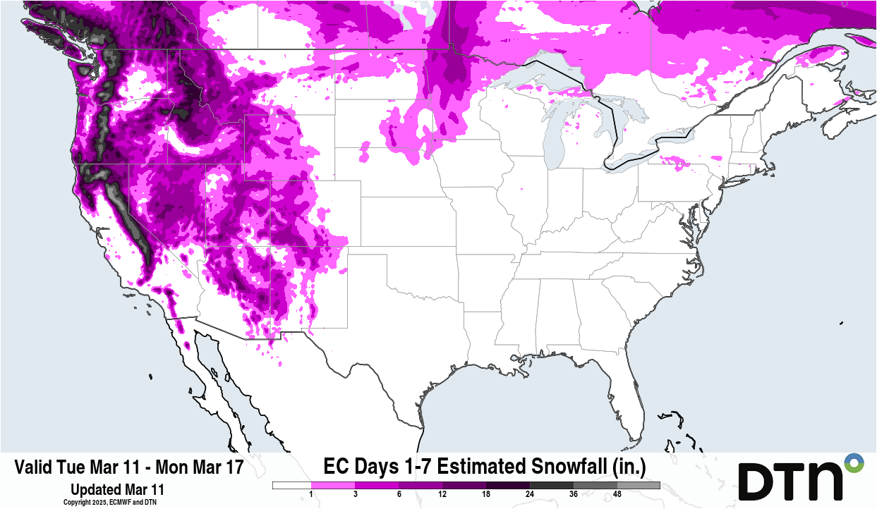
Image: Snowfall forecast from the ECMWF model shows a likelihood of heavy snow in the eastern Dakotas and Minnesota Source: DTN
Severe weather in the South
To the south, several more rounds of severe weather are currently being forecast by the Storm Prediction Center. Areas near the Mississippi River are the focus on Friday, with that shifting to the eastern Midwest down to the Gulf of Mexico for Saturday, and along the East Coast for Sunday. All hazards will be possible, but strong winds and tornadoes will be the main threats. Those outlooks will continue to be updated and can be found here: https://www.spc.noaa.gov/products/outlook/.
To go along with the threat of thunderstorms, heavy rain will be possible across the Gulf Coast and Mid-South, areas that have dealt with flooding recently and could have issues with more flooding.