Below average summer max temps for Melbourne
For Melbourne, it was the summer that never quite got going.
It was dry, and occasionally hot – with the first 40-degree day in three years and even a brief suspension of play due to heat at the Australian Open – but max temps in the Melbourne summer of 2022/23 were around 0.3°C below the long-term average.
As we write this story on Tuesday February 28, the full data set for summer is not quite in, but we can say with confidence that today's cool weather will do little to change the overall picture.
So here's what we can say early in the afternoon of February 28 about Melbourne's summer of 2022/23:
- The average max temp to date has been 25.0°C
- The long-term average summer max is 25.3°C
- There were 19 days over 30°C in Melbourne this summer, which is just below the long-term average of 21 days
- The hottest day was Feb 7 with a top of 40.5°C (the long-term summer average is 1 day of 40°C or higher)
- The coldest maximum temperature was a chilly 15.8°C on December 14
Why the cool weather when it was relatively dry?
We know that Australia's climate is slowly warming, but we also know that maximum temperatures can still be kept below average with persistent cloud and showers.
This isn't what happened in Melbourne over the 2022/23 summer. As you can see below, rainfall was below average in each month.
- Dec 2022 42.4 mm (long-term ave 59.1 mm)
- Jan 2023 20.2 mm (long-term ave 46.8 mm)
- Feb 2023 23.6 mm to date (long-term ave 48 mm)
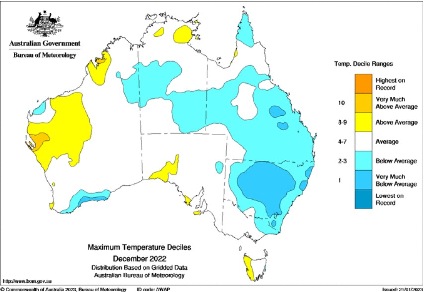
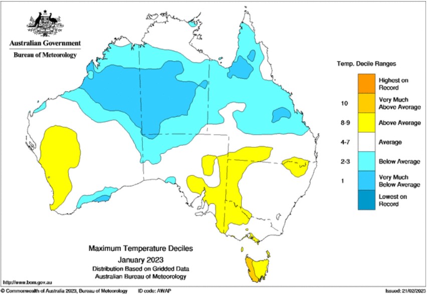
The likely explanation for Melbourne's slightly-cooler-than-usual summer max temps was a lack of widespread heat over the interior of the continent, which you can see on the two charts below (February is not yet available).

Image: Max temp decile map for December, showing where was warmer or cooler than usual. Source: BoM.

Image: Max temp decile map for January, showing where was warmer or cooler than usual. Source: BoM.
Summer heat for southern Australia is generated over the interior and tropics, before being advected (transported by wind) towards the southern coast, but as the maps show, it was relatively cool in the interior, and that affected temperatures elsewhere, including in Melbourne.
While Tuesday's cool weather on the last day of summer may feel like a fairly typical representation of Melbourne's summer that never quite was – with temps unlikely to reach 20°C – the autumn outlook is for a warm, dry autumn across most of Australia, Melbourne included.
The breakdown of La Niña and a neutral or positive Indian Ocean Dipole over the next three to six months are factors that typically cause drier and warmer weather than usual in Australia.