Australia put on La Nina watch
The Pacific Ocean is showing signs that it could be shifting towards La Niña, a pattern of wind and ocean temperatures that typically boosts rainfall in large parts of Australia.
.jpg)
-- What is La Niña? --
La Nina is one of three phases of a cycle called the El Niño-Southern Oscillation (ENSO). Each phase of the ENSO cycle - La Niña, neutral and El Niño - refers to a distinct pattern of sea surface temperatures and wind across the equatorial Pacific Ocean.
All three phases of ENSO affect the world's climate and weather in different ways. In northern and eastern Australia, the state of ENSO can mean the difference between a year dominated by drought or floods.
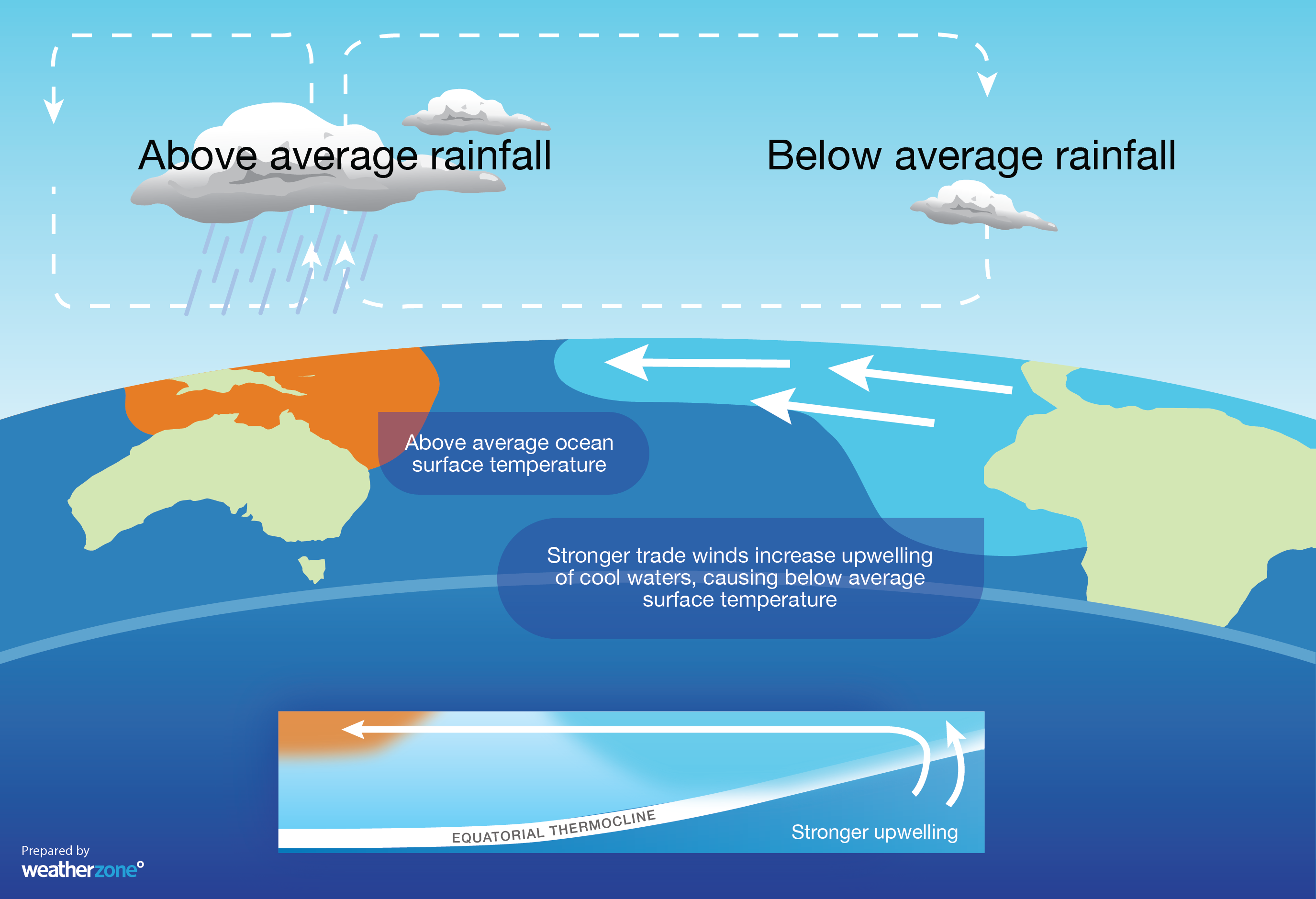
La Niña is sometimes called the cool phase of ENSO and it occurs when trade winds strengthen over the Pacific Ocean. This wind change causes cooler-than-average water to develop in the central and eastern tropical Pacific Oceans, while unusually warm water builds up in the western tropical Pacific. This pattern typically leads to above average rainfall in large areas of eastern and northern Australia, particularly in winter and spring. It also increases the likelihood of below-average daytime maximum temperatures over most of Australia outside the tropics, particularly during the second half of the year.

Image: The main characteristics of a typical La Niña event.
Neutral ENSO phases typically have little impact on the weather and climate of Australia, while El Niño usually promotes dry and warm weather in large parts of the country.
-- La Niña Watch --
The Pacific Ocean is currently in a neutral phase. However, there is a clear pattern of cooler-than-usual seas over the estern half of the equatorial Pacific and warmer-than-usual seas over western tropical Pacific. This pattern is La Niña-like. However, it will need to persist and strengthen further over the coming months to develop into a proper La Niña event.
Some international forecast models suggest that the Pacific Ocean will continue to trend towards La Niña during the rest of Australia's winter and early spring. However, some other models indicate that the Pacific Ocean could stay in a neutral phase right up to next summer.
It's too early to tell whether or not we are in the early phase of the world's next La Nina episode. But with the current state of the Pacific Ocean, and clear signs that some forecast models are heading further this way, the odds of La Niña developing later in 2020 are increasing.
In response to these signs, the Bureau of Meteorology increased their 'ENSO Outlook'; to La Nina Watch on Tuesday, 23rd June. This means there is a 50 percent chance of La Nina developing later in the year, which is roughly double the normal likelihood.
More information will become available during the next several weeks as the Pacific Ocean continues to evolve, hopefully giving us a better idea of what to expect later in the year.