Another big cold burst for U.S. following strong cold front this weekend
Temperatures are again set plummet across parts of the U.S. from this weekend after a strong cold front sweeps across the country.
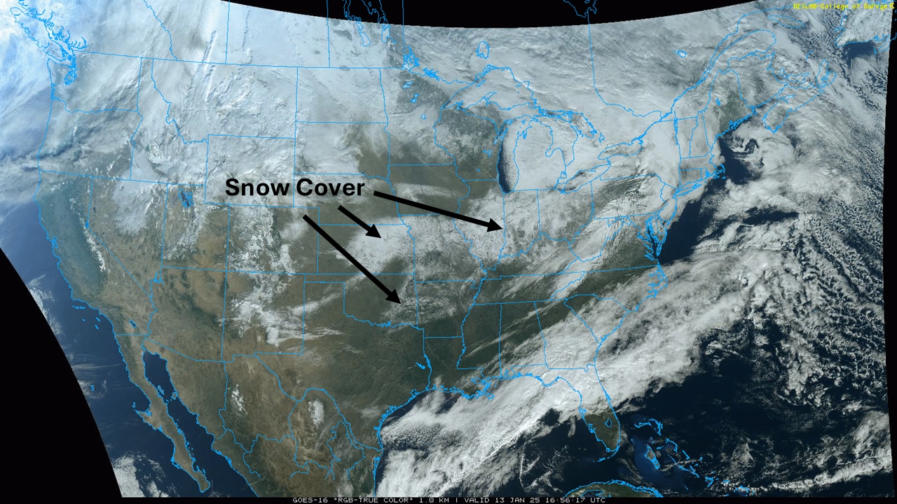
January 2025 has seen an overall cold pattern in place for most areas of the U.S. east of the Rockies. That has led to some unusually high snowfall totals for the southern half of the country from a couple of systems earlier this month.
One 6 to 12 inch band of snow fell across northeast Kansas and northern Missouri from January 4 to 6 and another 6 to 12 inch band fell across eastern Oklahoma, far northeast Texas, and central and northern Arkansas January 9 and 10. Outside of the intense snow bands, snowfall near or exceeding 6 inches also fell in parts of the Ohio Valley and Mid-South from both storms, respectively.
Some areas of the south have seen more snowfall than areas up north. Much of southern Minnesota, Iowa, and Wisconsin are in a ‘snow hole’ where much of the ground is either uncovered or with very little snow on the ground.
The recent snow also led to very cold temperatures in some areas, with temperatures down to -10°F in northeast Kansas.

Image: Snow cover from previous storm systems shown by satellite as of 11am CST, Monday, January 13. Source: College of DuPage
Mother Nature is now building up to bring yet another big burst of cold air to the US, but this time, the cold weather will be even more widespread.
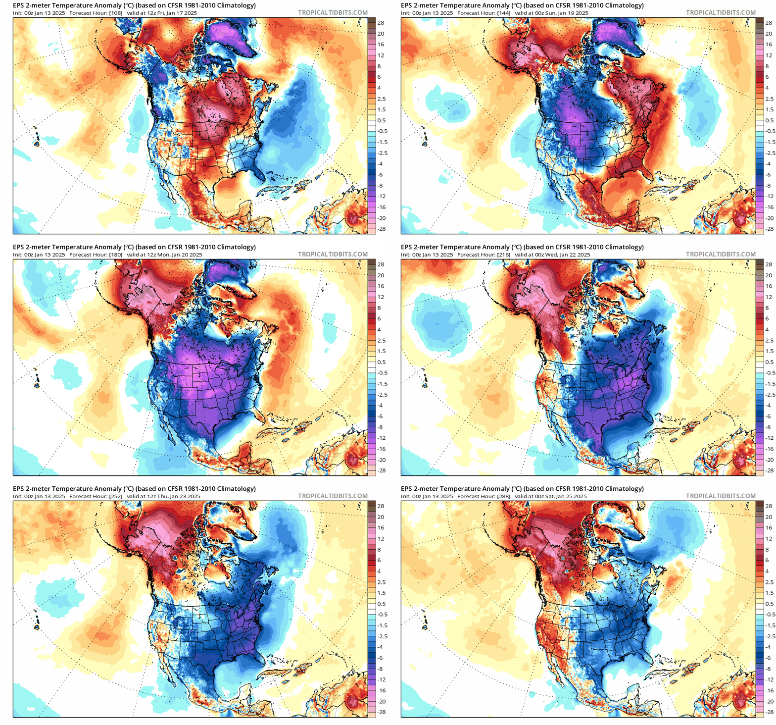
The upper-level pattern over the US will play a key role in this next round of arctic cold, allowing a massive pool of cold, polar air to spread across much of the continent from the North Pole to the Gulf of Mexico by early next week.
Usually, the Rockies provide a good barrier to these arctic intrusions, guiding them east of the mountains. For the coldest air, this will be true, but even the Rockies won’t be able to contain this immense cold pool, and it should seep westward into the Intermountain region as well.

Image: Forecast from the European Ensemble model shows cold air (in blue and purple) pushing from western Canada through the U.S. this weekend, lingering much of next week. Source: tropicaltidbits.com
Overall temperatures look to be coldest on Monday, January 20, but will be colder in the Northern Plains a day earlier and the East a day or two later. Widespread anomalies of 20-30 degrees below normal are expected for a couple of days and some peak areas that have fresh snow cover could see anomalies drop 40 degrees below normal. The last burst of arctic air failed to produce anomalies this drastic and widespread, but the one coming up has better potential to do this.
The front that brings in the cold air later this week may also develop a low-pressure center that could cover the Southern Plains through the Northeast January 18 to 20. Models are still working this aspect of the system out, but it could lead to a zone of fresh snow for the Midwest or Mid-South into the Northeast that could allow temperatures to get even lower than the current forecasts.
Any lingering snow from earlier in the month will also help to keep temperatures down as this next system comes through. A brief two- to three-day burst of above-normal temperatures this week should help to melt off some of the existing snow, especially for areas that were hit with the snow late last week across the south. However, those from Kansas eastward may not have warm enough temperatures for long enough to get rid of all the snow.
The harsh cold starting later this week will only last a few days, most likely about to three days for the most drastic temperature anomalies. However, colder-than-normal temperatures are likely to persist through the end of the week and could be reinforced by more cold air to close out the month of January.
What is unusual is that these bursts of cold are coming without an aid from the polar vortex. Over the last several years, many of these cold bursts we have seen have been in large part due to a disturbance in the polar vortex, or the jet stream that circles the North Pole. When the polar vortex gets disrupted, it often brings very cold air south, sometimes into North America, for extended periods of time.
The month of January is going to be a cold one for many in the U.S., but this time it will not be due to the polar vortex. This cold air is shallower and not as long-lasting as polar vortex events can be. This is brining getting short, but intense bursts of cold lasting only a couple of days before temperatures return closer to normal for a few days before getting hit again. By contrast, polar vortex events usually last more than a week at a time without interruption.