
Alfred delivers one metre of rain in five days
Rainfall observations from the past five days have revealed that parts of southeast Queensland received more than one metre of rain during Tropical Cyclone Alfred’s protracted landfall.
Rain associated with Tropical Cyclone Alfred started falling in eastern Australia around Tuesday and Wednesday last week while the system gradually approached the coast. This wet weather continued and intensified during the second half of last week as Alfred edged towards the coast, made landfall as a tropical low on Saturday night and then moved inland on Sunday and Monday.
Alfred’s drawn-out journey towards eastern Australia and its prolonged landfall exposed parts of southeast Qld and northeast NSW to a sustained period of rainfall. Within this multi-day soaking were shorter periods of intense rain that caused flash flooding.
At the longer timeframe of this event, some areas in southeast Qld received more than one metre of rain over the space of five days. Here are some of the standout accumulated rainfall totals during the 120 hours ending at 9am on Monday, March 10:
- 1111 mm at Upper Springbrook, Qld
- 1010 mm at Lower Springbrook, Qld
- 850 mm at Dorrigo, NSW
- 820 mm at Tallebudgera Creek Dam, Qld
- 721 mm at Huonbrook, NSW
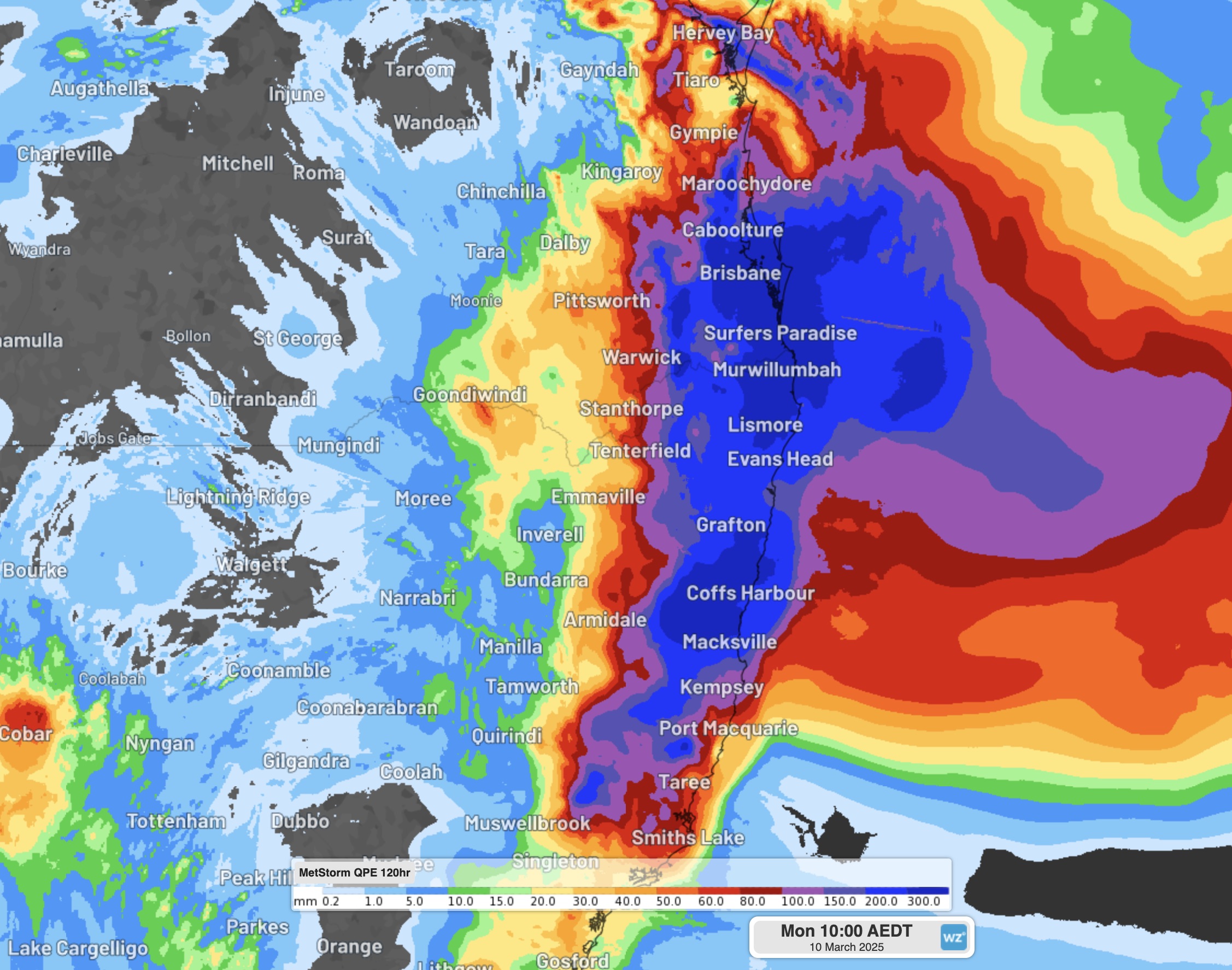
Image: A quantitative estimate of rainfall over eastern Australia during the 120 hours ending at 9am AEDT on Monday, March 10, 2025.
Some areas experienced their wettest day in decades during this event, including Brisbane, which had its wettest day since January 26, 1974. The biggest daily rainfall totals from the past five days occurred in the 24 hours to 9am on Monday, after Ex-Tropical Cyclone Alfred had crossed the coast, with some big totals including:
- 433 mm at Diamond Valley, Qld
- 410 mm at Wongawallan, Qld
- 391 mm at West Woombeye, Qld
- 357 mm at Kingsholme (Montego Hills), Qld
- 282 mm at Tomewin, NSW
- 275.2 mm at Brisbane, Qld
Shorter rainfall rates were equally immense, particularly when a convergence line in the wake of Alfred’s core caused heavy and slow-moving thunderstorms over parts of southeast Qld on Sunday into Monday morning.
Here are some notable rainfall rates from southeast Qld and northeast NSW over the last few days:
- 224 mm in 3 hours on Sunday morning at Hervey Bay, Qld
- 147 mm in 3 hours and 207 mm in 6 hours on Sunday night at Kingsholme (Montego Hills), Qld on Sunday night
- 112 mm in 3 hours early on Monday morning at Maleny, Qld
- 105 mm in 1 hour on Sunday afternoon at Fred Haigh Highway, Qld
Video: The Queen Mary Falls in southern Qld responding to Alfred's rain. Source: @my_australia_downunder / Instagram
The rain associated with Tropical Cyclone Alfred and its remnant low pressure system has caused widespread major riverine flooding and flash flooding in southeast Qld and northeast NSW over the past few days. This flooding has cut off numerous roads in both states, and rivers are likely to remain elevated for days as the floodwaters make their way downstream.
Check the latest flood warnings and severe weather warnings in your area for the most up-to-date information and do not attempt to drive through floodwater. A small car can be moved by as little as 15 cm of flowing water, while 60 cm is enough to wash the vehicle away.