
After SA deluge, Tas disappears off weather map
Almost 30 locations in the Adelaide Hills and nearby areas have seen very heavy rain totalling more than 50 mm in the 24 hours to 9 am Friday, with a top reading of 96 mm at Woodhouse, near Mt Lofty.
As we wrote in our SA story yesterday, the rain was quite unusual in that it was very persistent, rather than arriving in bursts of heavy showers. The heaviest rain fell between midday and midnight, although lighter falls continued until well after dawn on Friday.
The heavy rain in the Hills caused flash flooding, with emergency services responding to hundreds of calls for help. Fortunately, heavy rain has now cleared the area, with only light showers persisting into Friday morning. Heavy rains cause flooding and road closures in Adelaide Hills with people rescued by SES - ABC News
- Adelaide registered 41.6 mm to 9 am, bringing the current monthly tally as at 9 am Friday to 67 mm
- That potentially puts it on track for its wettest June since 2012, when a total of 126.4 mm was recorded, as further heavy rain is likely on Saturday through to Sunday morning
Meanwhile the trough and associated low pressure system that brought the Adelaide area downpour is now tracking east across Victoria and far southern NSW, with a rainband currently dampening paddocks and pavements all the way south to Melbourne. The Australian Alps can also expect further snow this afternoon after light-to-moderate falls on Thursday night.
Heavy cloud is also covering Tasmania. Somewhere in that combined satellite and radar image below lies Australia’s island state.
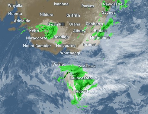
The heaviest Tasmanian rain on Friday should be confined to the east of the state. Hobart saw a healthy 22.6 mm overnight and had already notched a further 4.8 mm by 11:00 am.
We sometimes tend to think of Tassie having its own weather that is unrelated to what's happening on the mainland, but today's soggy conditions are all part of the same broad weather system that broad heavy rain to SA and that is now crossing Vic and southern NSW.
Indeed, Tasmania is experiencing a northeasterly stream this Friday, which is the same (somewhat unusual for winter) direction that the winds came from during Adelaide's Thursday drenching.
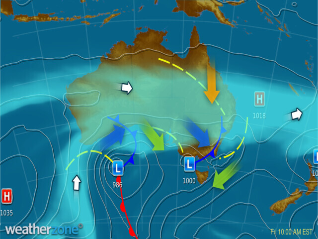
The green directional arrow on the synoptic chart above shows how this is all part of one big system, with air circulating clockwise around the low and moist northeasterlies streaming in off the Tasman Sea to Tasmania's east coast.
Unsettled weather will persist for most of southern Australia for at least the next few days as this complex system of lows, cold fronts and troughs continues to cross the region.