
A triangulation of lows
Australia is sandwiched between two tropical low pressure systems to the north and one mid latitude low to the south.
Satellite imagery shows three swirls of cloud associated with areas of low pressure. Although the characteristics of these systems are very different- they have one main thing in common, rising air. This rising air causes air to cool and condense into clouds- and once these clouds are thick enough, they bring rain.
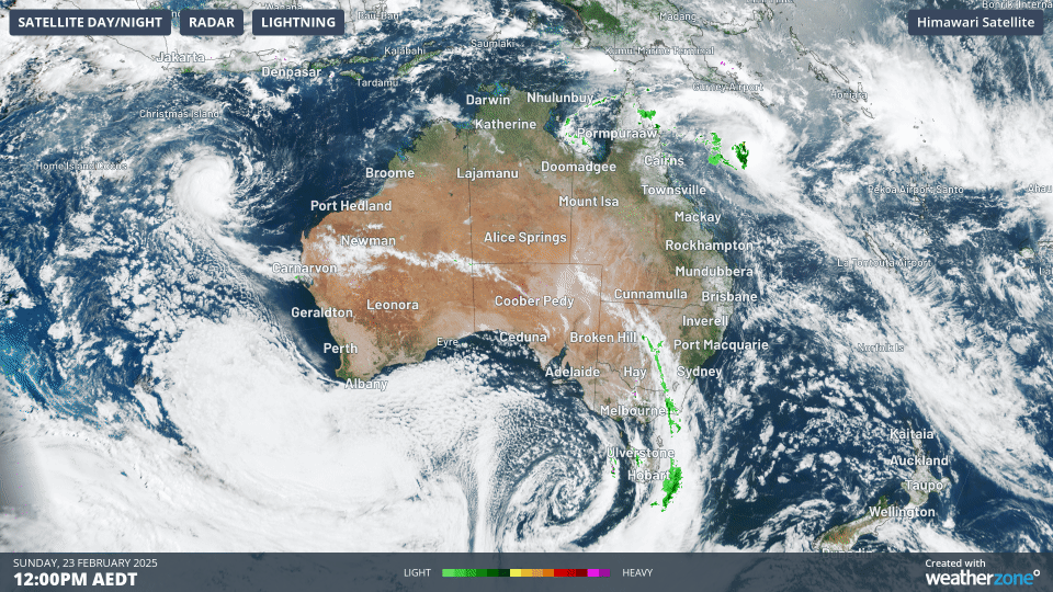 Image shows satellite loop on Sunday 23rd Feb 2025 showing 3 low pressure systems.
The swirl of cloud to the north of WA is Tropical Low 21U and is currently drifting westwards towards the Indian Ocean. It's expected to become a tropical cyclone over the coming days and then intensify into a category 2 system. The system will then likely head southwards over the Indian Ocean and dissipate as it moves over increasingly cooler waters and less favourable atmospheric conditions. At this stage the system is expected to be approximately 1000km due west of the WA coast, far enough away to minimise any impact to the Australian mainland.
The swirl to the east of Cape York is Tropical Low 22U and is expected to imminently develop into a tropical cyclone. This system is then forecast to track east and then southeast in the coming days potentially becoming a category 3 system by mid-week. A lot of uncertainty in the forecast regarding the track of this system and meteorologists will be keeping a close eye in the coming days. In the short term this system is not expected to bring any significant weather impacts to Australia. The next two tropical cyclones to form in the Australian region will be named Alfred and Bianca.
The third swirl is associated with a mid-latitude system meaning its formation is linked (in part) to contrasts in airmass rather than warm ocean temperatures that are responsible for their tropical cousins. This low pressure system is introducing cooler and fresher westerly winds into southeast Australia in the wake of some hot northerlies. This can be seen on the satellite image as speckled cloud and is often associated with showers. The dividing line between these air masses is a cold front (and associated trough) bringing some thunderstorm activity to parts of eastern Victoria, Tasmania and southeastern parts of New South Wales. This can be seen on the satellite imagery as a band of white cloud with the high tops of cumulonimbus clouds. This front is spreading eastwards and introducing the fresher conditions.
As you can see, plenty of weather to keep our team of Meteorologists busy over the next week or so. To keep up to date with the latest satellite imagery and forecasts visit our website Australian Weather Satellite