
10 weather words to make you sound more like a meteorologist
This week is National Science Week in Australia and to help budding meteorologists step up their skills, we are taking a look at 10 technical terms that will have you sounding like a professional forecaster in no time.
Isobar
Isobars are the lines you see on a weather map forming rings around the ‘L’ and ‘H’ symbols. An isobar is a line that connects points of constant pressure in the atmosphere. On a typical map, isobars show mean sea level pressure near the surface. When the isobars enclose the ‘H’ symbol it represents a high pressure system. When the isobars enclose the ‘L’ symbol it represents a low pressure system. Isobars that are tightly bunched together reflect a strong pressure gradient, which is associated with strong winds.
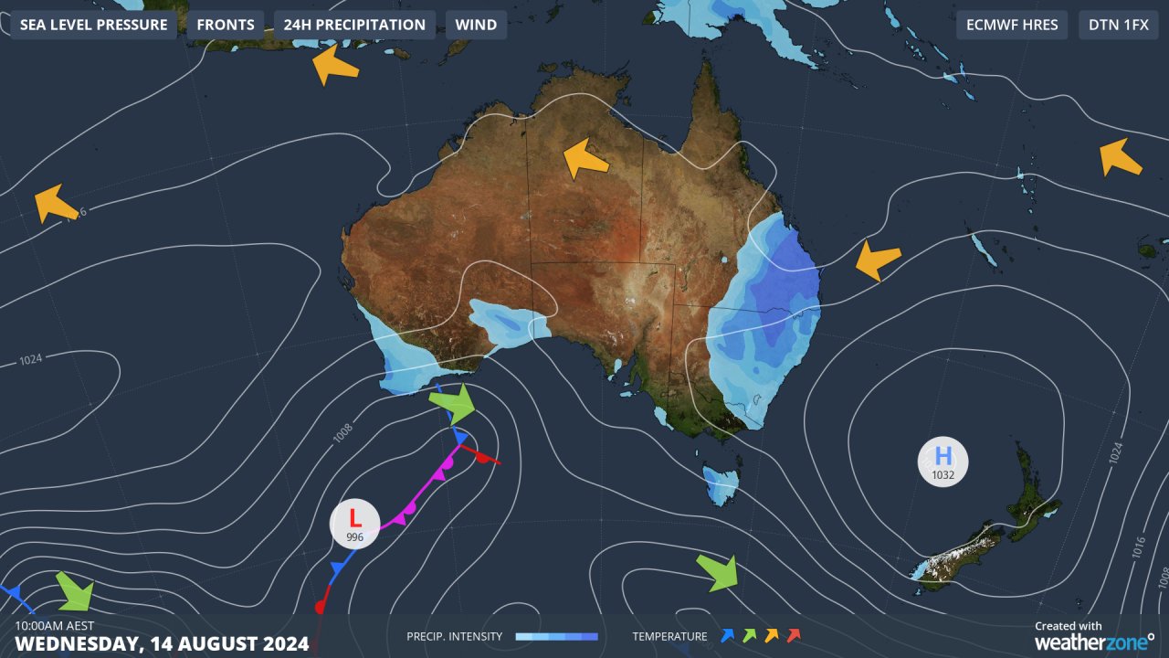
Image: A synoptic chart showing isobars connecting points of equal mean sea level pressure.
Thickness
The term thickness can refer to the distance between any two pressure levels in the atmosphere, although it typically refers to the depth of the layer that lies between 1000 and 500hPa, which is roughly the lowest 5 to 6 km of the atmosphere.
The thickness of the atmosphere is related to the temperature within that layer; lower thickness represents colder air, and higher thickness represents warmer air.
Atmospheric thickness helps meteorologists identify upper-level troughs or ridges and pinpoint cold and warm air masses. These elements are all important to find where different types of weather are likely to occur. For example, when the 5400 m thickness line (1000-500 hPa) is located to the north of the Australian Alps, it is typically cold enough for snow at the main ski resorts.
Foehn (Föhn) Effect
The Foehn effect, also known as the Föhn effect, is the warming effect of air flowing down the leeward side of a mountain range. This phenomenon can cause air flowing over a mountain range to end up being warmer than it was before it reached the mountains.
The Foehn effect works like this:
- As air rises up the windward side of a mountain it cools.
- If there is sufficient moisture in the air as it rises, then this moisture will condense and produce clouds and sometimes rain or snow.
- As this air descends the other side of the mountain, it becomes warmer because air warms more quickly with descending height when it is drier.
The Foehn effect is one of the reasons Sydney can reach very high temperatures in summer (due to northwesterly winds from the Blue Mountains), and rarely gets extremely cold in winter (thanks to southwesterly winds off the Southern Tablelands).
Orographic Lifting
Orographic lifting refers to the lifting of air caused by its passage up and over a mountain range or other sloping terrain.
Orographic lifting forces air to rise higher into the atmosphere, which allows it to cool at a faster rate. This cooling can enhance condensation when there is enough moisture in the air, resulting in clouds and rain or snow. Meteorologists are always on the lookout for orographic lifting when rain-bearing systems are occurring near mountains because this phenomenon can greatly enhance rainfall rates and the risk of flooding.
Vorticity
Vorticity is a measure of the rotation in a fluid flow. In meteorology, vorticity can refer to the rotation around a vertical or a horizonal axis.
Vertical vorticity can help meteorologists identify areas of rising and sinking air in the atmosphere, while horizontal vorticity is useful to determine how much wind shear is occurring, which can help predict thunderstorm intensity.
Haboob
A haboob is a strong dust or sandstorm caused by powerful winds lifting dust or sand high into the atmosphere. Haboobs can be triggered by the strong winds flowing out of thunderstorms in the storm outflow, or from powerful winds associated with strong cold fronts.
Haboob just hit I-8 near Stanfield! #azwx @NWSPhoenix pic.twitter.com/P4NLXYHg5q
— Mike Olbinski (@MikeOlbinski) August 3, 2018
Haboobs reduce visibility and can deposit large quantiites of dust and sand over a broad region. In Australia, strong dust storms have deposited red dust from the Australian outback into the snowfields in New Zealand.
Virga
Virga is rain that falls from a cloud but evaporates before it reaches the ground. In certain cases, shafts of virga may precede a small downburst of air called a dry microburst, which is caused by cold and dense air rapidly descending towards the ground.
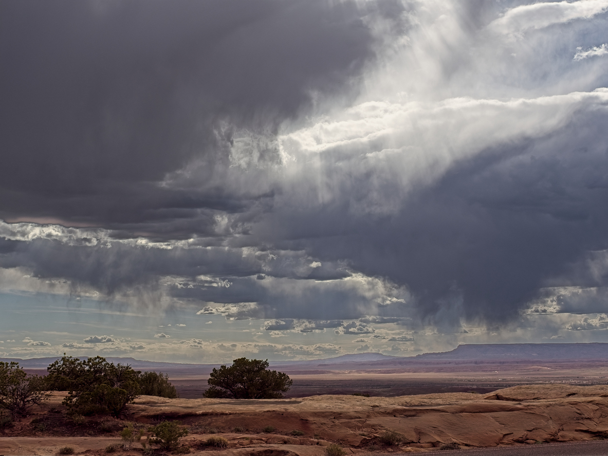
Image: Virga in Arizona, USA. Source: Peter Blottman Photography / iStock
Meteotsunami
Meteotsunamis are large shallow-water waves created by sudden changes in air pressure in the atmosphere directly above the water. They can be triggered by cyclones, thunderstorms, squall lines, strong cold fronts and atmospheric gravity waves. Meteotsunamis can reach above 5 metres in height and cause unexpected flooding in low-lying coastal regions.
Feels Like Temperature
The 'feels like’ temperature is an estimation of the temperature a person is feeling based on the current weather conditions. The ‘feels like’ temperature takes air temperature, wind speed and relative humidity into account. During dry and cold days in winter, the ‘feels like’ temperature is typically several degrees below the actual air temperature. Conversely, a hot summer’s day with high relative humidity and low wind speeds will produce a ‘feels like’ temperature that is considerably higher than the actual air temperature.
Dew Point
The dew point refers to the temperature to which the air must be cooled in order to reach saturation, at which point condensation will occur. The dew point is affected by the amount of moisture in the atmosphere; when there is more moisture in the air, the dew point will be higher and when the moisture content of the atmosphere is lower, the dew point is lower.
Dew point helps meteorologists predict the likelihood of fog. It is also a useful indicator for how uncomfortable people will feel on a hot day. As a rough guide for most areas of Australia, dew point temperatures 20 to 24°C will start to make people feel uncomfortable, while dew point temperatures of 25°C and higher will feel oppressive and may cause heat stress.