
Remarkably Unremarkable Weather
In a week where it seemed like the weather gods were working overtime, it now seems like they’re completely spent and have taken the weekend off.
It was only a week ago that Sydney copped a drenching with a few hundred millimetres of rain and major flooding in Western Sydney. Tropical Cyclone Olga then brought heavy rain and gale force winds to the Pilbara. Meanwhile, on the other side of the country a cold front dumped the first snowfall of the year on mainland ski resorts. That same cold front developed into a low pressure system over the Tasman Sea which was responsible for the hazardous surf and wild winds along the NSW coast during the week.
Further inland, floodwaters continue to fill Kati Thanda-Lake Eyre while floodwaters over inland southern Queensland make their way down the upper parts of the Darling catchments.
If that wasn’t enough, there was blink-and-you’ll-miss-it Tropical Cyclone Paul which barely lasted more than 24 hours over the Coral Sea. Finally, while strictly speaking not a meteorological phenomenon (but rather, an astronomical one), a full solar eclipse over the US made headlines around the world.
So where does that leave us now? Well, mostly dry and partly cloudy over the major eastern capitals just about sums it up. Autumn and spring are well known for their wild swings in weather in Australia but for the next week or so, those are notably absent. Take my hometown of Melbourne for example. It’s not unusual to see April temperatures well into the 20s, even pushing 30 degrees, only to be hurled back into the mid-teens by a strong cold front. This week however, there’s only 2 degrees of variation in the maximum temperatures.
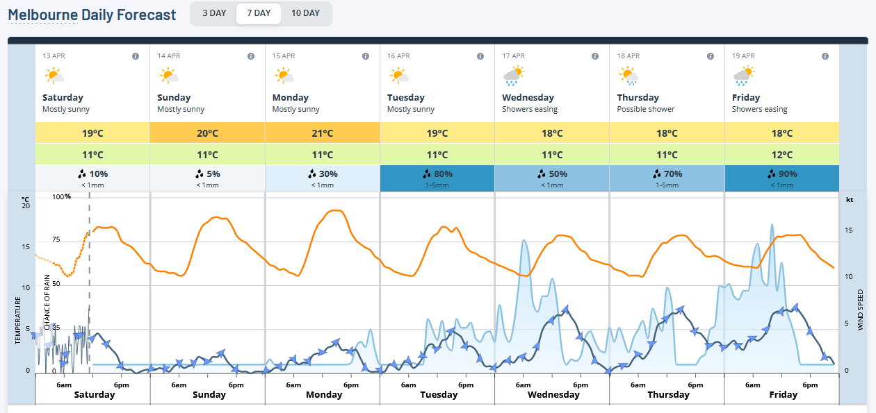
Image: Melbourne forecast for the next 7 days.
After all the cold fronts, lows and tropical cyclones, a big fat blocking high pressure system has moved in over the Great Australian Bight. Often during summer, we associate blocking highs with heatwaves particularly in Adelaide and Melbourne but that’s when the high sits over the Tasman Sea and directs persistent, hot northerly winds over the cities. Blocking highs can however produce the pleasant, unchanging and, if I’m perfectly honest, somewhat boring weather that awaits us next week.
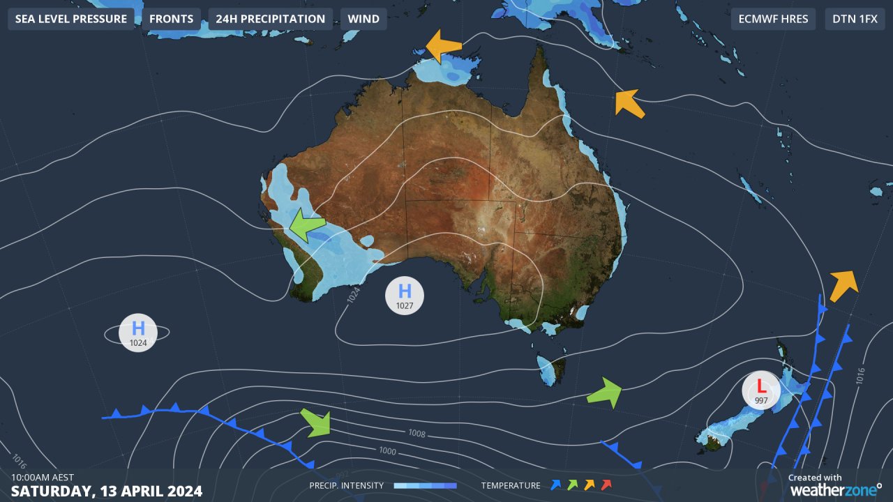
Image: Australian synoptic map for Saturday, note the high over the Bight.
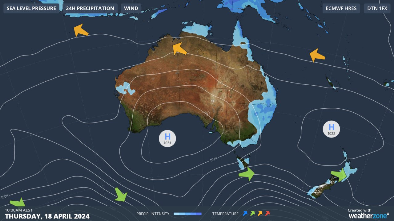
Image: Australian synoptic map for Thursday. Despite a weak cold front crossing southeast Australia in the early part of the week, the high over the Bight remains the dominant feature.
Because the atmosphere behaves as a fluid (albeit a compressible fluid), I like to make analogies to other fluids to explain what’s going on. Think of a creek or a small river. Now imagine you roll a big rock or boulder into the river. The water then has to flow around the rock and it takes a lot of energy (say, a flood) to move the rock. It’s almost the same with a blocking high. Cold fronts tend to be deflected away and even the jet stream in the upper levels of the atmosphere can split to flow around the high. It takes a particularly strong weather system or a major change in the jet stream to break down the system (or ‘move’ the rock in the stream). Only then will we start to see major fluctuations in the weather again. But in the meantime, enjoy the stable weather for the next week or so!