Rain, rain, go away, Byron Bay is soaked again
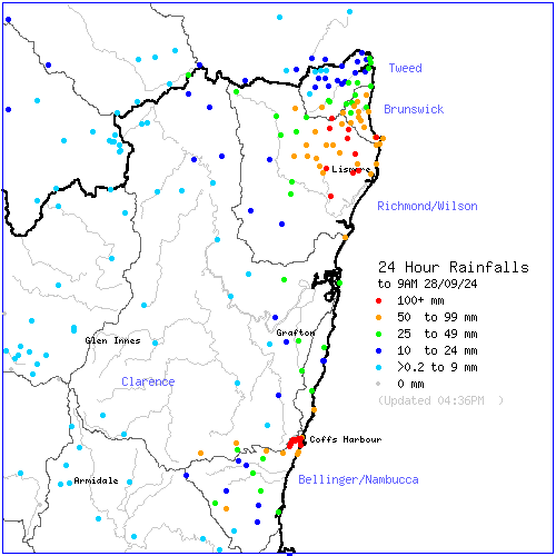
A low pressure system off the coast of southeast Qld and northeast NSW has delivered substantial rainfall to the NSW Northern Rivers and Coffs Harbour regions, with some areas experiencing their highest daily September rainfall in years to 9 am this morning, Saturday, September 28.

Image: 24-hour rainfall to 9am, Saturday, September 28, 2024. Source: Australian Government Bureau of Meteorology
Byron Bay has been hit particularly hard by this system. The town copped quite a drenching overnight, with 91.6mm falling in the gauge to 9am today —its highest daily September rainfall since 1982. Cape Byron, the easternmost point of Australia, recorded its highest daily September rainfall in 26 years, with 75.4 mm in the gauge. That particular spot has also been lashed by damaging southerly winds, reaching 100km/h or more at times since early yesterday afternoon, peaking at 117km/h yesterday and 104km/h (so far) today.
Meanwhile, Rosebank recorded its highest daily September rainfall in 36 years with a 24-hour total of 116mm to 9am today. Ballina Airport’s daily total of 83.2 mm to 9 am today was its highest daily September rainfall in 6 years.
Some weather stations in the region also registered their highest daily September rainfall on record this morning, although it should be noted that these stations have only been operating for a decade or two:
- Evans Head RAAF base – 95.2mm (highest in 26 years of records)
- MacLeans Ridge – 120.8mm (highest in 24 years of records)
- Nashua – 112.0mm (highest in 23 years of records)
- Corndale – 90.0mm (highest in 23 years of records)
- Bentley – 66.0mm (highest in 23 years of records)
- Lismore Airport – 78.0mm (highest in 22 years of records)
Further south, Coffs Harbour Airport copped 101.6mm, which is its highest September rainfall in 11 years of records. Other stations in and around Coffs Harbour recorded between 110mm and 170mm to 9am, with the highest reading of 164mm in 24 hours recorded at Loaders Lane, about 5km northwest of the airport.
But it hasn’t ended there, especially in the Northern Rivers. In just the six and half hours between 9am and 3:30pm today
- Doon Doon received 83mm
- Terania Creek received 72mm
- Alstonville received 64mm
- Goonengerry received 59mm
- Mullumbimby received 56mm
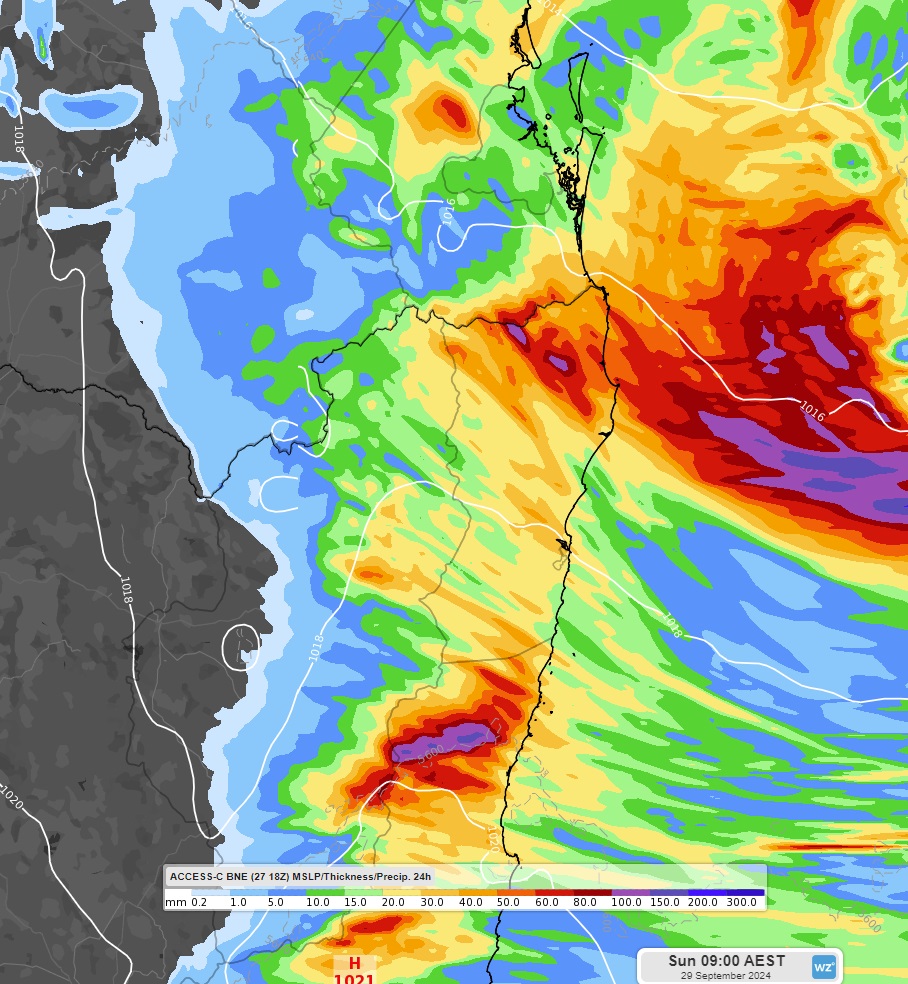
And more is on the way. Forecast models are currently predicting that the same areas which saw such heavy rainfall to 9am today could see another 100mm or more in the 24 hours to 9am tomorrow.
 Image: Access-C’s forecast 24-hour rainfall over northeast NSW and southeast Qld to 9am, Sunday, September 29, 2024.
Damaging winds should ease along the northern NSW coast this evening but push north onto the southeast QLD coast and along the Qld-NSW border ranges overnight. Severe weather warnings have been issued for these states, so please make sure you keep up to date with them here.